A better quantitative grasp of cold-air outbreaks will improve the way they are represented in earth system models
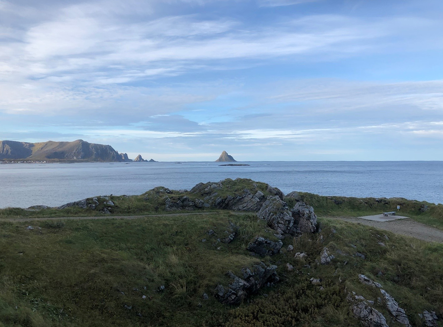
In the northernmost reaches of Norway, within the Arctic Circle, is a narrow island called Andøya—a place of peat bogs, rocky beaches, and steep mountain ranges the color of lichen. Its administrative center, Andenes, has been a fishing village since the Iron Age.
The island points like a finger to the icy edge of the Arctic Ocean 1,000 kilometers (620 miles) away and (as it turns out) is the ideal place for investigating cold-air outbreaks. These globally common―and climatologically significant―atmospheric phenomena occur when a cold air mass confronts open areas of warm water.
To look into how these cold-air outbreaks unfold, University of Wyoming atmospheric scientist Bart Geerts and collaborators are using data from the U.S. Department of Energy’s (DOE) Atmospheric Radiation Measurement (ARM) user facility.
In part, they are doing so through a new ARM field campaign, the Cold-Air Outbreaks in the Marine Boundary Layer Experiment (COMBLE). With Geerts as principal investigator, researchers will look at the shallow convective cloud formations that start at the Arctic Ocean’s ice edge during cold-air outbreaks and evolve as they progress over open water towards Andøya.
In writing the COMBLE science plan, Geerts enlisted the help of about 20 people from 15 institutions in the United States, Norway, Sweden, and Germany.
The field campaign, slated to run from January through May 2020, is linked to a larger study of mixed-phase convective clouds in the polar marine boundary layer. It is funded by the DOE’s Atmospheric System Research (ASR) program, and with Geerts also in the PI role.
To round out their study, the researchers will combine COMBLE data with measurements collected at ARM’s North Slope of Alaska atmospheric observatory and during a 2017-2018 ARM field campaign called Measurements of Aerosols, Radiation, and Clouds over the Southern Ocean (MARCUS).
Sobering Facts
Worldwide, shallow convective cloud regimes play a key role in the Earth’s energy balance. In high-latitude marine boundary layers, such clouds are part of the atmospheric backdrop for two sobering facts.
For one, ice cover in the Arctic is declining faster than any earth system models have predicted, pointing to a need to improve those models.
For another, temperatures in boreal regions (including the Arctic itself) are increasing twice as fast, on average, than anywhere else on Earth, a phenomenon known as “arctic amplification.” The boreal ecosystem, including an interlocking circumpolar band of subarctic forests and bogs, covers large areas of far northern Scandinavia, Russia, and Canada.
Cold-outbreak clouds happen elsewhere in the world, including over open oceans bordering Alaska, in the Southern Ocean, and in the Sea of Japan, which is periodically penetrated by cold air churning southward from Siberia.
These cloud regimes that have not been studied much, says Geerts, “yet they are important in understanding global warming and the amplification of warming in boreal regions.”
In turn, he says, a better quantitative grasp of cold-air outbreaks will improve the way they are represented in earth system models.
Questions and a Quest
Worldwide, shallow convective clouds over oceans have more effect on Earth’s energy balance, measured as radiation, than any other cloud regime. However, little is known about the properties of the clouds formed during cold-air outbreaks or about processes within the boundary layer.
“We don’t know, for instance, whether the clouds are primarily liquid, or ice, or mixed-phase,” says Geerts. “We don’t know how precipitation forms, how heavy it is, and we don’t have a good understanding of the recirculation of moisture back into the ocean.”
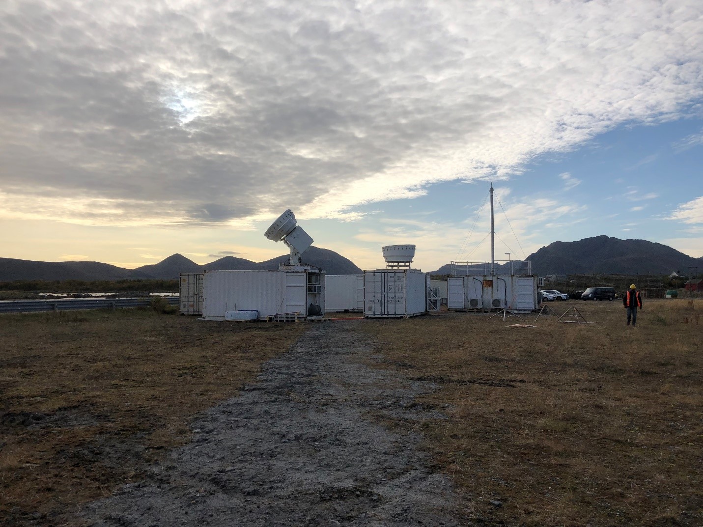
To get the most out of their work on cold-air outbreaks, Geerts and his team made a facility request to ARM, which two years later set in motion two instrument installations.
Yin and Yang
Warm air intruding into the Arctic causes rapid warming. At the same time, in what Geerts calls “extrusions,” cold air is pulled out of the Arctic and sweeps over warm water.
“These extrusions, if you like, or outbreaks, are basically the yin and yang of the baroclinic (temperature and pressure) variations that occur across the thermal boundary,” he says.
Geerts says yin is the relatively warm water to the south; yang is the ice cover to the north.
Among results of the two competing influences are the storms that move across the region and pump warm air into the Arctic. Knowing more about these events is part of the science mission of an international expedition coincident with COMBLE and scientifically collateral—the Multidisciplinary Drifting Observatory for the Study of Arctic Climate (MOSAiC) field campaign. It will do most of its work much further north than COMBLE, collecting data on the effects of diminishing ice cover on the Arctic’s atmosphere, ice, ocean, and ecosystem.
While MOSAiC researchers measure warm-air intrusions into the Arctic, says Geerts, COMBLE will look “at the other side of that equation, where cold air moves over open water. In that way (the two campaigns) are quite coupled.”
Polar Partners
A breakout session co-led by Geerts at the June 2019 Joint ARM User Facility/ASR Principal Investigators Meeting in Maryland established that MOSAiC and COMBLE represent “some of the most sophisticated suites of instruments to ever be deployed in the Arctic.”
Session organizers also held that the two campaigns will capture critical regional-scale measures of cloud and atmospheric processes related to large-scale air flows into and out of the Arctic.
COMBLE and MOSAiC will collaborate with another coincident field campaign, ArctiC Amplification: Climate Relevant Atmospheric and SurfaCe Processes and Feedback Mechanisms, otherwise known as (AC)3. Organized by three universities and two non-university research institutes in Germany, (AC)3 will investigate the processes contributing to amplified temperatures in the Arctic.
(AC)3 will document evolving air masses by using research aircraft flying between northern Scandinavia and the drifting MOSAiC site.
Together, (AC)3, COMBLE’s two sites, and MOSAiC will comprise what Geerts calls “four supersites” that are uniquely arrayed to profile clouds, aerosols, precipitation, and radiation in and near the Arctic.
Logistical Advantages
COMBLE can easily share experts with MOSAiC, which originates in Tromsø, Norway. That’s just six hours by car from the field campaign’s main observatory on Andøya.
The campaign is also a dual deployment—a logistical asset,” says Geerts, in a region of persistent open water that experiences more wintertime thermal instability than nearly anywhere else on Earth.
COMBLE instruments will be situated about 1,000 kilometers (620 miles) from the ice edge as well as on an island halfway in between—all the better to capture the evolution of cloud formations during cold-air outbreaks.
“Climatology suggests it’s the place to be,” says Geerts.
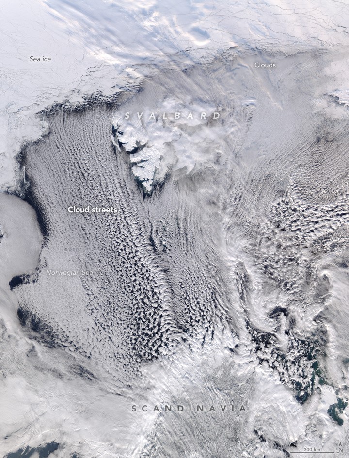
In COMBLE’s study area, outbreaks initially create linear “cloud streets” over the Norwegian Sea. They gradually break into cellular “comma” clouds as an outbreak event moves southward to Andøya and Scandinavia at large.
“We really want to understand this transition from linear to cellular cloud formations,” says Geerts. “Hopefully, Bear Island will be in the right location to capture both mesoscale organizations.”
Continuous Operations
COMBLE researchers are collaborating with the Andøya Space Center Observatory, a Norwegian service center for ground and aerial research platform near the seaside village of Bleik.
Whenever cold-outbreak conditions appear, technicians at the center will launch eight radiosondes a day. (Geerts designed a predictive mechanism that provides outbreak-alert warnings five or more days ahead.)
The Norwegian technicians will also collect samples of ice-nucleating particles during periods of intensified measurements during outbreaks.
Two ARM technicians will watch over AMF1 during the campaign’s five months; Norwegian technicians will operate the instruments on Bear Island. From his office in Wyoming, Geerts will watch and guide the measurement-taking.
“There’s really no need to be out in the field,” he says. “But in a warming Arctic, there is great need for COMBLE data.”
# # #This work was supported by the U.S. Department of Energy’s Office of Science, through the Biological and Environmental Research program as part of the Atmospheric System Research program.