Second Intensive Operational Period Concludes for Green Ocean Amazon Campaign
Scientists have now completed the first half of the interagency Green Ocean Amazon (GOAMAZON) campaign, a two-year study to determine how Mother Nature interacts with pollution from a city of 2 million people and the impact that interaction has on the pristine and delicate climate of Brazil’s Amazon Basin. Attacking the project from above and below during two vastly different seasons, the team uses a battery of scientific instruments—including the ARM Mobile Facility, Mobile Aerosol Observing System, and ARM Aerial Facility—to collect atmospheric data and understand what happens when the emission plume from the city of Manaus encounters natural emissions from the Amazon rainforest. The ultimate goal is to improve the accuracy of climate models to help understand and predict how the climate is evolving as human activities increase.
“The Amazon Basin is roughly the size of the continental United States,” according to Scot Martin, Harvard professor of environmental chemistry and lead scientist for GOAMAZON.
“There are various plans to develop parts of the area in the future and we want data from both seasons to compare how pollution affects cloud physics and chemistry, atmospheric and ecosystem functioning, air quality, and other conditions downwind of Manaus. We hope what we learn there and what we know about the impact of future human activity on a planetary scale can be helpful in guiding development while keeping pollution to a minimum as much as possible.”
The first intensive operational period (IOP) for the two-year study took place in February and March 2014 during the “rainy season,” when daily rainstorms dump more than 3 inches of moisture on the lush canopy of the forest. The second IOP, just completed in September and October, is providing an opportunity to measure atmospheric conditions during the “dry season.” For the Amazon rainforest, however, “dry” is a relative term that would be considered relatively wet in the Western United States.
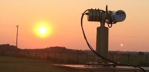
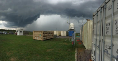
The ground attack takes place southwest (downwind) of Manaus at the Manacapuru (T-3) site where two 20-foot sea containers equipped with a total of 20 instruments measure the size distribution, concentration, chemical and optical properties, and other characteristics of gas-phase pollutants and aerosols passing overhead.
Difference Between Wet and Dry
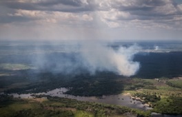
Scientists have observed major differences in atmospheric aerosols during the wet season compared to the dry. Daily rains in the wet season temporarily cleanse aerosols from the air until the Manaus plume drifts downwind again. In the dry season, however, fewer rainstorms and additional aerosol sources, such as forest burning or land clearing, combine to create more airborne particles than in the wet season.
Allison Aiken, a Los Alamos National Laboratory scientist and operations manager of the ARM Facility’s Mobile Aerosol Observing System (MAOS), says one challenge with gathering data is accurately discerning whether or not the Manaus plume is over the site or whether the site is impacted by other local sources.
“At one point, we thought we would be able to compare our data from the time our instruments are taking measurements in the plume with the times when they are sampling clean background conditions,” she explains. “But there are other sources, such as small-and large-scale burning, not related to the Manaus plume and we get aerosols from them sometimes, as well, which further complicates the data analysis.”
The airborne research effort collaborates closely with the ground operation. Four scientists aboard the DOE supported Gulfstream-1 research aircraft, operated by ARM Aerial Facility, make multiple passes across the Manaus plume as far as 60 miles downwind of the city. The aircraft’s 25 instruments gather real-time measurements that help the team characterize the aerosols in the atmosphere and measure physical properties of clouds, such as droplet size.
Searching for a Baseline
Readings from the aircraft, especially those taken directly over the T-3 site, complement and help validate data obtained on the ground. In addition, the plane encounters more pristine conditions outside of the plume at higher altitudes, especially after rainstorms, providing a better “starting point” for comparisons than is available on the ground.
Size and quantity of aerosol particles can influence the weather, according to Jason Tomlinson of Pacific Northwest National Laboratory, who is an AAF payload scientist on the excursions. “We know pollution typically makes cloud droplets smaller since there are more particles to act as seeds to collect water,” he explains. “Because there is a finite amount of moisture spread out among more particles, the droplets are smaller. Bigger droplets have a better chance of colliding and coalescing to create rain than smaller droplets. So pollution can delay the onset of precipitation and even decrease precipitation.”
Data being gathered helps scientists get a better picture of what is happening in the atmosphere and how it affects the climate. The information will eventually be used to develop better computer models for predicting future changes in the weather and climate.
“Our aircraft is a complete package. We can measure aerosols, gases, and properties of the clouds,” Tomlinson adds. “We’ll be able to answer a lot of the questions we have and be better able to model the weather systems in and around the Amazon rainforest and study the long-term impacts of human activities on the Earth’s climate. The data will help modelers understand how pollution is being added to the atmosphere and being taken out by the heavy rains. We can’t change things, but we hope to bring the world to a better understanding of how vital the Amazon is and how delicate of an ecosystem it is.”
Armed with data from the first two IOPs, the team has begun analyzing their findings in collaboration with Brazilian scientists, who are taking extensive measurements at other ground-based sites near Manaus. The combination of DOE and Brazilian measurements will provide a comprehensive picture of the Manaus plume and its impacts. The ARM Mobile Facility will remain in Manacapuru through December 2015 when the GOAMAZON campaign concludes. Data from the DOE ground observations are currently available in the ARM Data Archive for all scientists to use to help refine existing models of the Amazon Basin Ecosystem in hopes of predicting the near- and long-term impacts of current trends. Aircraft observations will be made available in the ARM Data Archive by early summer.
# # #
Green Ocean Amazon is sponsored by the U.S. Department of Energy through the Office of Science’s Office of Biological and Environmental Research and collaborates with Amazonas Research Foundation (FAPEAM), São Paulo Research Foundation (FAPESP), and National Science Foundation (NSF). For a list of specific projects, see the GOAMAZON collaborations page.
The ARM Climate Research Facility is a national scientific user facility funded through the U.S. Department of Energy’s Office of Science. The ARM Facility is operated by nine Department of Energy national laboratories.
Studying the Amazon Basin’s Climate by Air and by Land
Published: 15 January 2015