Journal article outlines an international campaign to study the impact of African fires
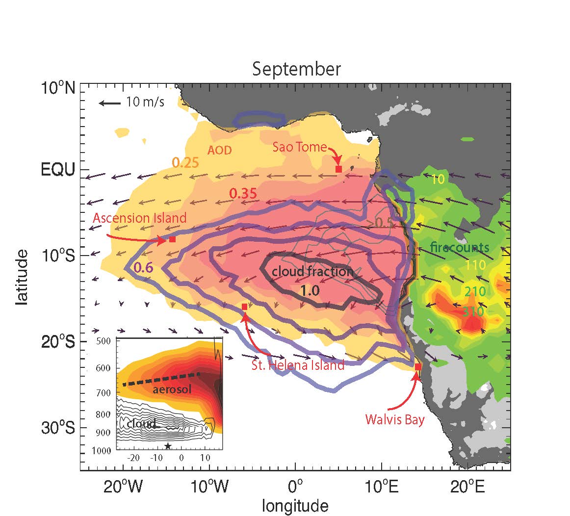
A map of large-scale fires in the world is dominated by a broad red slash across the continent of Africa. From July through October, intense emissions of biomass burning aerosol (smoke) rise from the savannas of southern Africa and blow westward over the southeastern Atlantic Ocean. These vast sheets of black carbon travel through the free troposphere, just above one of the largest stratocumulus cloud decks on Earth.
The cloud-smoke climate regime that results is thought to have a significant effect on the Earth’s radiation budget—that is, how much sunlight either absorbed or radiated back into space. But the effects of high flying smoke on climate are not well understood. Moreover, such emissions (which account for 86 percent of total black carbon soot across the globe) are still not well represented in climate models.
To the rescue is an international climate research collaboration that just got underway in June. From June 2016 through October 2017, scientists from five nations will investigate the little known interplay of smoke and clouds over the southeastern Atlantic. University of Miami atmospheric scientist Paquita Zuidema is lead author of a paper that outlines the long-term study’s science, design, necessity, and coordinating players. Online now, it will appear in the July issue of the Bulletin of the American Meteorological Society.
The combined campaign includes scientists from the United States, United Kingdom, France, South Africa, and Namibia. For all of them, getting better and more data over more time and space is the key. “Existing sparse data sets,” wrote Zuidema in the paper, “highlight the need for in situ data of important climate variables.”
For Good Data, Good Instruments
World-class data from the most comprehensive study of its kind so far will require a comprehensive suite of instruments, some of them mounted on the three aircraft taking part in 2016. NASA-funded planes will operate at staggered intervals over a three-year span and will be based in Walvis Bay, Namibia. Coordinated ground instruments are in place in Africa and on Ascension Island and are planned for the nearby island of St. Helena.
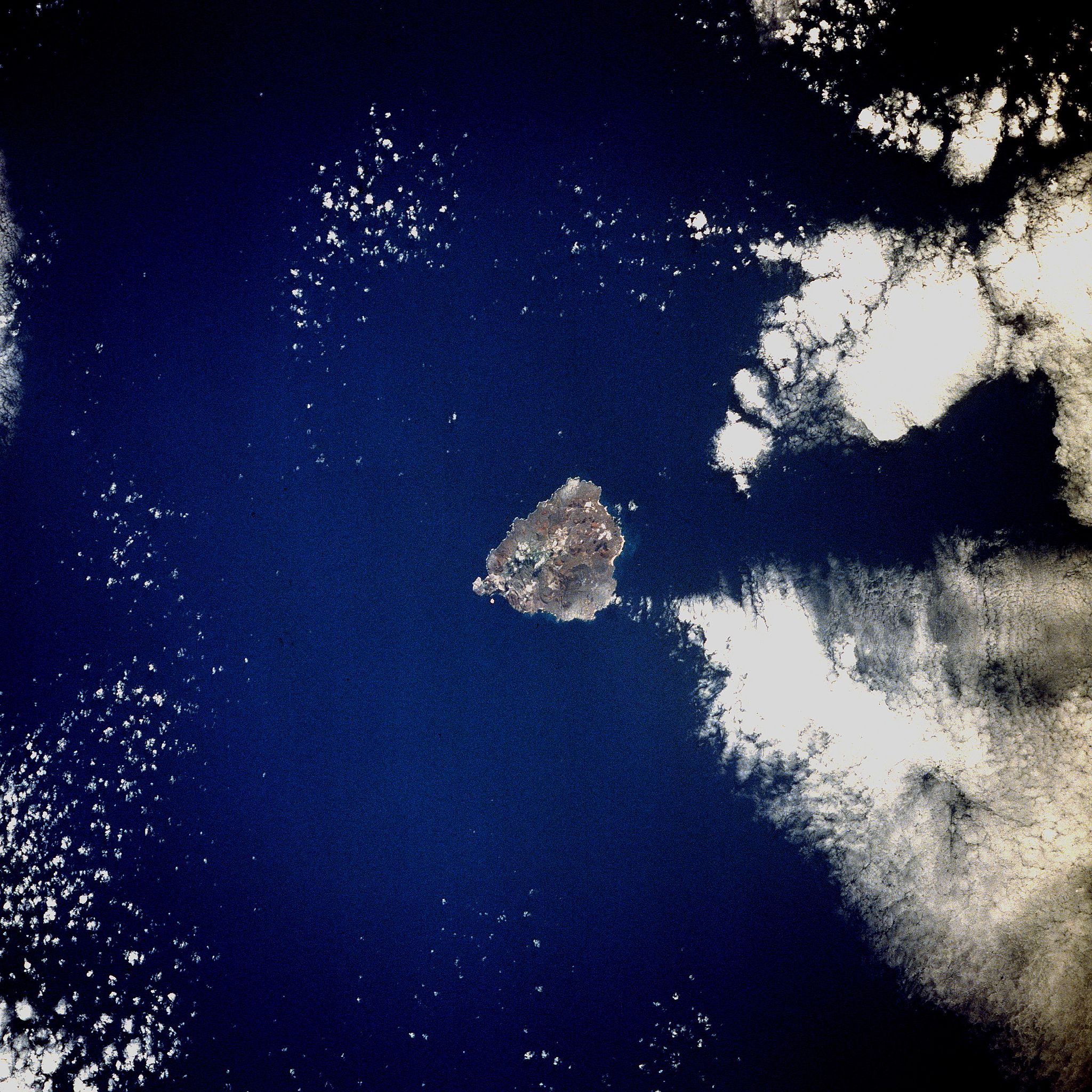
Zuidema oversees one of the American research collaborations, a U.S. Department of Energy (DOE) field campaign called Layered Atlantic Smoke Interactions with Clouds, or LASIC. From June 1, 2016, through October 31, 2017, LASIC will be based on tiny Ascension, a volcanic speck midway to Brazil on the east and 2,000 km to the west from Africa. The island, just 34 square miles big, is science’s southeastern Atlantic bullseye. It’s well situated for observing cloud-smoke interactions because it lies right beneath the main aerosol outflow pathway that smoke from African fires follows across the ocean.
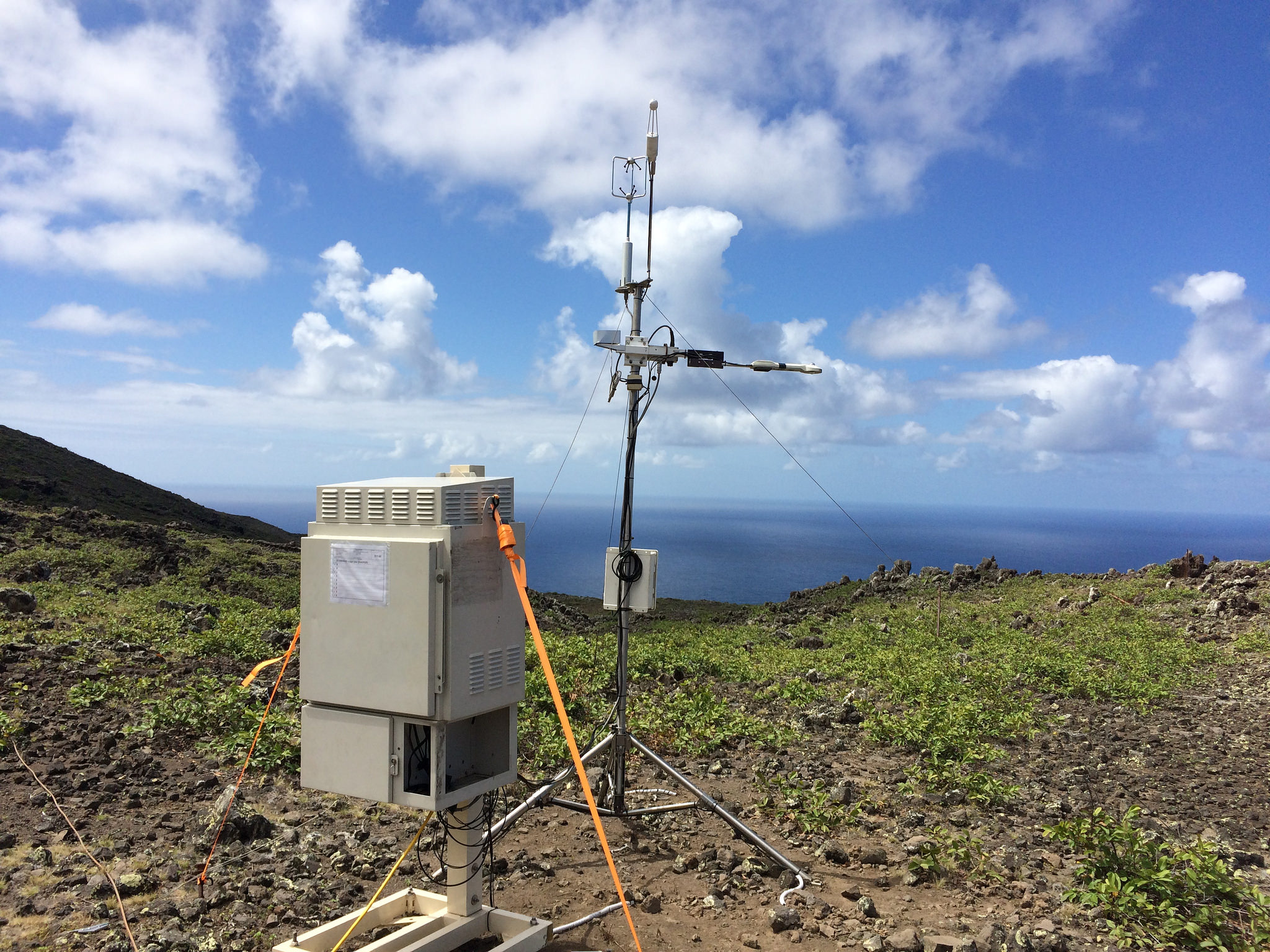
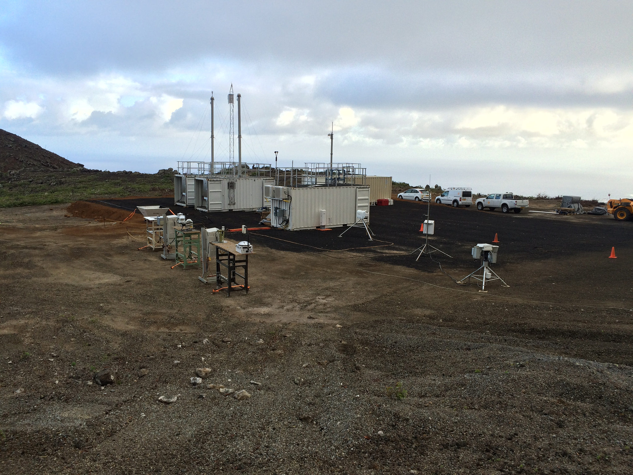
Deployed on Ascension for atmospheric profiling is the first of the DOE’s Atmospheric Radiation Measurement (ARM) Climate Research Facility’s three mobile facilities, known as AMF1. The basic mission is to gather data on how the properties of smoke evolve after their long-range transport through the atmosphere, in particular their ability to absorb shortwave radiation. It is also to assess how such smoke affects low clouds.
“The smoke provides one of the largest climate warmings from aerosols on the planet,” said Zuidema. “However, how low clouds respond to the presence of smoke can change the net climate impact of the smoke from a warming to a cooling.” But so far, she added, the processes by which the low clouds adjust to the presence of smoke are not fully known.
An Instrumented Island
Ascension is situated in warm, near-equatorial waters and within a trade-wind cumulus cloud regime. With the island’s deep boundary layer of clouds and with its long distance from the origin of biomass burning, or BB in Africa, there is a chance that the transported smoke will be mixed into the cloud layer, the paper says. That would give scientists a good opportunity to study how clouds and smoke interact.
The LASIC deployment of ARM instrumentation on Ascension is on a flat field carved from rocky terrain, with pointed island peaks just beyond, dappled with green. It has a lot of measurement capacity, including in situ and remote aerosol sensors; cloud remote sensors, including a lidar to profile the vertical structure of cloudy skies; and several cloud radars. Multiple balloon-mounted radiosondes will be launched every day. The clusters of instruments aboard, beaming data back by radio, “will provide the first characterization of the diurnal cycle,” the paper reads, “with and without smoke present overhead.”
With and without smoke present, how will the aerosol flow affect the evolution of the boundary layer as it moves between Ascension and St. Helena? Dual instrumentation on the islands, the paper says, will give scientists a first-time chance to examine that.
This five-nation science collaboration, of course, will also take to the air. During its ORACLES project, NASA will supply both a Lockheed P-3 Orion turboprop, first designed to hunt submarines, and a Lockheed ER-2 high-altitude science aircraft, a relative of the storied Lockheed U-2. The P-3 will spend August 20 and 21 on Ascension as part of its transit to Namibia. Zuidema will be on the flight to that coastal African republic and will use August 20 to take video and stills of the AMF1 site.
For their CLARIFY project, U.K. scientists will deploy the FAAM (Facility for Airborne Atmospheric Measurements) BAe-146 aircraft, a modified short-haul airliner. The U.K. aircraft will deploy out of Ascension September 1 to 21. During that same timeframe, the NASA campaign is planning a science suitcase flight from Namibia to Ascension and back. “Suitcase science” instrument packages, a concept developed by NASA, are light, portable, and automated.
Beginning in 2017, French scientists will use a Dassault Falcon 20, a modified business jet equipped with high-resolution lidar for a long-term aerosol study with South Africa and Namibia called AEROCLO-SA.
During one half of the overall campaign, survey flights along regular lines of latitude and longitude will help with comparisons of climate models. The remaining flights will assess the direct radiative effect of the smoke (BB) aerosols. Instruments aboard will also measure, the paper says, changes “in atmospheric stability, circulation, and cloud properties.”
To maximize airborne resources, scientists will make an effort to range farther out into airspace to survey conditions in the larger Atlantic basin.
Improved Models the Aim
All of this might help with what the paper lays out a central motivating fact: “The complexities of the southeast Atlantic climate are not currently well captured by models.”
The climate science collaboration could help improve models in several ways, the paper says: by getting better data on how smoke aerosols are distributed spatially and vertically; by assessing their capacity for absorbing shortwave radiation; and by finding a way to better represent the atmospheric physics of the low cloud deck.
It’s all important. Current climate models foresee future warming for Africa, along with variations in rain patterns. Meteorology already shows what the paper says is a “strong coupling between the atmosphere, ocean, and land” of the oceanic region under study. And it is already known that a land-based anti-cyclone in southern Africa sometimes draws airborne smoke back to the continent.
Many questions remain, the paper says, in part because the smoke-clouds interaction regime as it is understood to date is largely the product of satellite studies, widely spaced photometers on land (though NASA will soon provide more), and modeling simulations. Researchers maintain that both LASIC and aircraft are needed to fully characterize and understand aerosol-cloud interactions at the “process” scale, that is, within data measurement grids of approximately 100 meters square.
But the project is designed to make a difference, the paper says. It has the synergy of atmospheric science projects from five nations, aircraft, ARM instrumentation on two critical islands, and a commitment to gathering years of data, day, and night.
“Significant progress can now be made,” wrote Zuidema in the paper, calling for even more research partners. “The opportunity for complementary science over the remote Atlantic exists until October 2018 … and much longer within Namibia.”
This work was supported by the U.S. Department of Energy’s Office of Science, through the Biological and Environmental Research program as part of the Atmospheric System Research program.