An ASR science team is ‘poised to reinvent our sense of stratocumulus clouds’
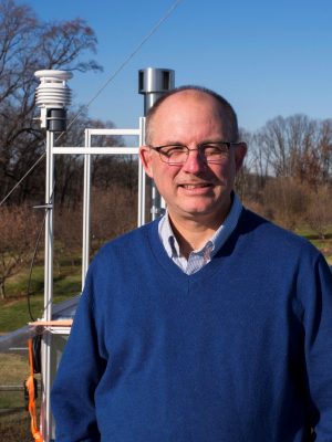
Mark Miller is a Rutgers University professor of meteorology who studies the atmosphere’s boundary layer, the turbulent first kilometer of the atmosphere where most weather happens.
In 1989, he was a student at Pennsylvania State University when he traveled to the Azores with his PhD advisor Bruce Albrecht, a pioneer in the study of marine clouds.
They were in search of a site for measuring low marine clouds, in preparation for a campaign conceived by Albrecht called the Atlantic Stratocumulus Transition Experiment (ASTEX).
Low marine clouds form a little-understood cloud regime that ubiquitously occupies the skies over the world’s oceans, bodies of water that account for 75 percent of the Earth’s surface.
“The presence or absence of such clouds deeply affects the local and global radiation budget,” says Miller. “We need to know more about them if we are to understand how the global climate functions.”
“Radiation budget” refers to the exchange of solar and terrestrial energy that keeps planetary conditions in equilibrium.
Despite the importance of low marine clouds, earth system models do not adequately represent how they are structured and how they are influenced by aerosols, the cloud-making particles that arise from both nature and human activity.
Hence the attraction of the Azores, an ocean-bound instrument platform of sorts. Researchers can site instruments there, close to marine clouds. And the islands are attractively influenced by aerosols from nearly everywhere, pure or polluted: North America, Europe, and even the Arctic.
“We have to thank (Albrecht) for recognizing the importance of the Azores as a laboratory for study,” says Miller, “and for having the foresight to understand the important role remote sensing would play in the study of this cloud system.”
Science on an Oval Dot of Land
Miller’s first visit to the Azores nearly 30 years ago bore fruit by 1992. In June of that year, on an island called Santa Maria, he took measurements and helped deploy the first radar instruments within a regime of marine stratocumulus clouds.
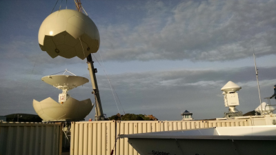
Today, Miller has a greater role than ever in the study of marine clouds. He is one of three members of a science team for the Atmospheric Radiation Measurement (ARM) user facility’s Eastern North Atlantic (ENA) atmospheric observatory on Graciosa Island, an oval dot of rocky land in the Azores six miles long and four miles wide.
The uniquely instrumented observatory, almost five years in operation, is funded by the U.S. Department of Energy (DOE) and is the locus of projects underwritten by DOE’s Atmospheric System Research program.
On the ENA science team, Miller is joined by University of Washington professor of atmospheric sciences Robert Wood, an expert in cloud-aerosol interactions who also studies the effect of precipitation on aerosols, and how aerosols impact precipitation and the structure of clouds.
“He has done fundamental work that has led to a deeper understanding of stratocumulus,” says Miller, and “his view of this cloud system is more global than mine.”
Wood has studied marine low clouds off the coast of Chile, for example, and the marine stratocumulus that reside over the south-central Atlantic. He also saw the early promise of ASTEX and wrote a 2005 paper using data from that 1992 experiment.
The third team member is Pavlos Kollias of Stony Brook University and Brookhaven National Laboratory in New York. He has made significant contributions to the design and operation of modern cloud radars. He specializes in creating data products derived from the ENA’s landmark array of radars—and specifically how radars can accurately predict precipitation and shed light on aerosol-cloud interactions.
Kollias is also helping to craft radar configurations that will improve estimates of marine drizzle; that will better estimate precipitation fields; and that will expand the “soda straw” field of view of some radars—all the better to estimate cloud structures and precipitation cells over larger areas.
X-band radars have only been operational at the ENA for a few months, says Wood, “but these scanning radars are going to give us a lot.”
Of the team, he says, “Each of us has different interests scientifically.”
However, all three share in the ENA science team’s mission, which according to Wood is “to accelerate the science, to guarantee data of good quality, and to make sure data algorithms produce useful products—what people want and need for their analyses.”
Science in Three Phases

In 1992, on Santa Maria Island, Miller and others spent a month collecting then-rare data on marine stratocumulus clouds for ASTEX.
The experiment was funded by NASA and the National Science Foundation “to actually look at what the fundamental cloud structure was like in that area,” he says. “At the time, that was a mystery.”
The Penn State team knew they were in the right place.
“We realized it was a valuable place to make measurements,” says Miller, despite “terrain effects” on Santa Maria. These orographic features on the rugged island created turbulence when clouds moved from gliding over the smooth sea to bumping over hills and other obstacles.
Low-lying Graciosa does not present the same problem, he says of today’s site. Scientists have also figured out how to algorithmically purge data of such anomalies.
ASTEX turned out to be the first of three phases of Azores cloud science, each richer and better instrumented than the one before.
Even after that one month in 1992, says Miller, it was obvious “a long-term data set was needed,” along with more and better technology.
In 2007, a DOE workshop charged with identifying a candidate for a new ARM observatory named the Azores as a place offering the best scientific value. In the early 1990s, ARM itself had considered the Azores as a potential site, but started with observatories in Oklahoma, Alaska, and the western Pacific.
During the workshop, “marine layers bubbled to the top as an important issue,” says Wood, and with them “the Azores came back again.”
It was not until 2009 that the second real Azores cloud science phase rolled in, with an ARM mobile facility field campaign based on Graciosa called Clouds, Aerosol, and Precipitation in the Marine Boundary Layer (CAP-MBL).
Back then, “Rob suggested we make measurements in the Azores,” says Miller, thrilled to this day at being able to go back to a place he calls “almost home” and to a rich and still critical research regime that once inspired his dissertation. “Going back was a literally a great moment in science for me.”
At the time, Wood was lead scientist for CAP-MBL, and Miller was chief scientist for what was then ARM’s only mobile facility—roles that not long after positioned them nicely (along with Kollias) to write a science plan for a proposed fixed observatory, the ENA, which began operations in September 2013.
CAP-MBL’s 19 months of data, says Miller, “provided a list of questions that needed to be answered and set the table for our realization that this cloud system was so complicated that it was going to take a long-term data set and a lot of statistics to really understand how these clouds work.”
Nearly a decade later, with the ENA in full instrumental bloom, the data set emerging “is poised to reinvent our sense of stratocumulus clouds,” he adds.
In part, says Miller of his “personal ENA report card,” that sense of hope is because of a unique array of instruments now on Graciosa, including an X-band ARM precipitation radar that sweeps large areas of sky.
“It’s the culmination of 20 years of R&D,” he says of the observatory. “Most of the tools we need are there. It is as complete as it could be right now.”
Storm Tracks, Drizzle, and the Future of the ENA
To Miller, the next few years of ENA science will help answer a couple of big questions, including why marine clouds seem to drizzle so sporadically.
Drizzle is a little-understood factor in the lifespan of low marine clouds, which in general have a cooling effect on Earth. In turn, if drizzle increases in a warmer climate, it may change cloud fields from unbroken, cooling fields to broken-cell cloud fields that could accelerate greenhouse warming.
Miller also sees a chance of the ENA helping to contextualize low marine cloud systems, and in particular link them to the dynamics of large storm tracks.
Meanwhile, the drumbeat of measurements from the ENA observatory provide the kind of long-term data set that helps define the variability of aerosol effects, says Wood. And it will help modelers find better ways to represent vertical turbulence that unfolds at scales of 100 meters to 1 kilometer. (Global predictive schemes are scaled to grids 100 kilometers wide.)
The ENA, he thinks, will also help global models incorporate phenomena on the mesoscale of 10 to 20 kilometers: a scale at which clouds and precipitation cells typically organize.
“We think we can learn a lot” about informing global models with mesoscale data, says Wood. “But we are still in the early days.”
Early or not, the ENA represents a leap for scientists investigating low marine clouds, a regime traditionally hard to measure simply because the clouds are out over the trackless oceans.
But Graciosa sits there like a giant surface ship bristling with the latest instruments. That gives researchers a chance for not only long-term data, but also for a close look at how marine low clouds work at the scale of particles and droplets.
“We have to understand the basic physics,” says Miller. “Then we can put together simulations in a numerical model.”
# # #
This work was supported by the U.S. Department of Energy’s Office of Science, Office of Biological and Environmental Research as part of the Atmospheric System Research Program.