Remote Sensing of Cirrus Cloud Vertical Size Profile Using MODIS Data
Submitter
Ou, Szu-cheng — University of California, Los Angeles
Area of research
Cloud Distributions/Characterizations
Journal Reference
Science
Based on the time series of backscattering coefficients derived from lidar and radar returns, cirrus clouds show significant vertical inhomogeneity in terms of extinction coefficient and ice water content. In situ balloon-borne ice crystal replicator data have shown that the variation of ice crystal size and shape distributions within mid-latitude cirrus clouds tend to be stratified: small non-spherical or quasi-spherical ice crystals are predominant in the upper layer, pristine single ice crystals and bullet rosettes with well-defined hexagonal shapes are prominent in the middle layer, and the bottom layer mainly contains larger but irregularly shaped aggregates formed by collision and sublimation processes of ice crystals. The vertical inhomogeneity of cirrus clouds, in addition to horizontal variability, is significant in producing the spatial variation of atmospheric radiative heating/cooling rates and the consequence of dynamic processes in the atmosphere.
Impact
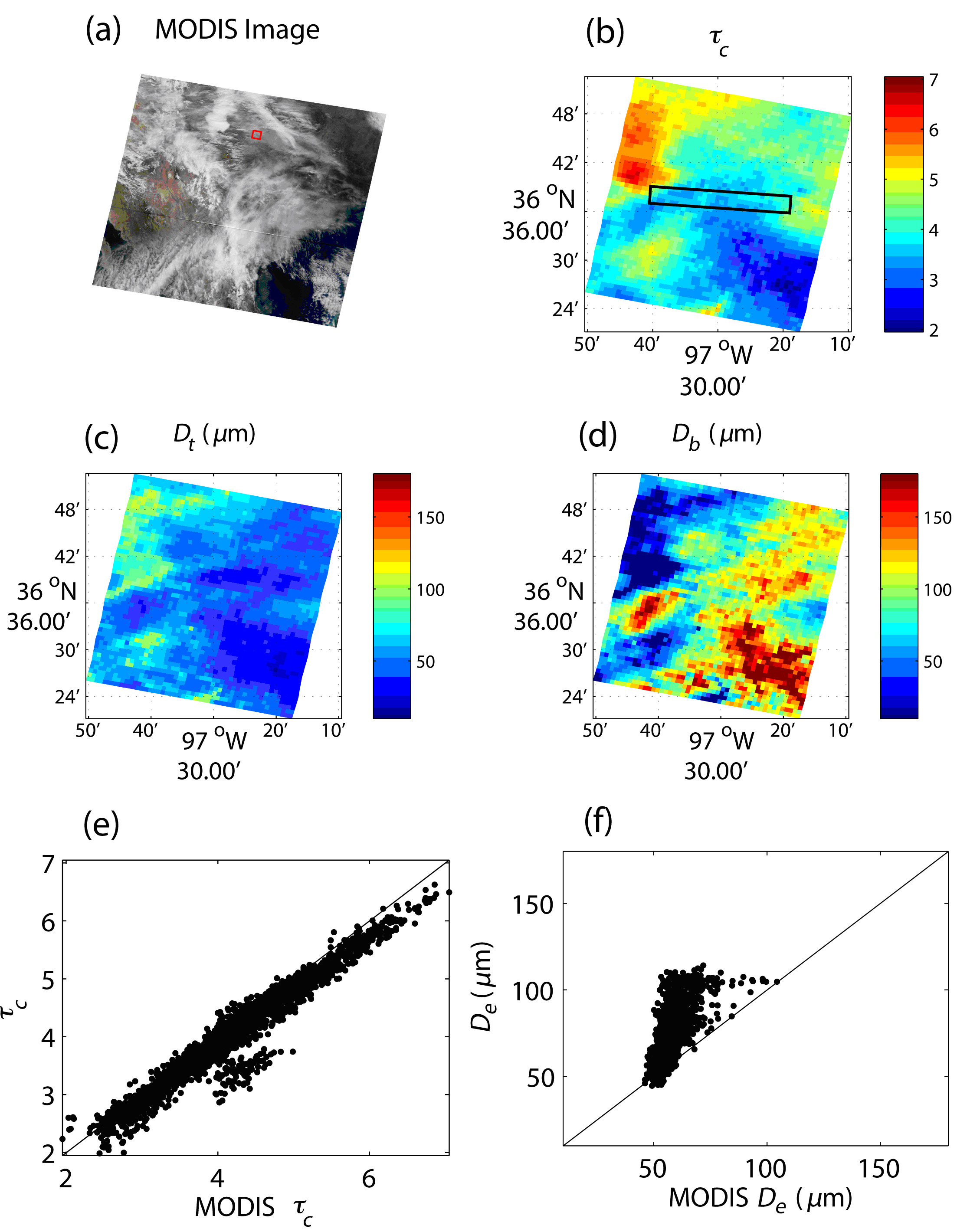
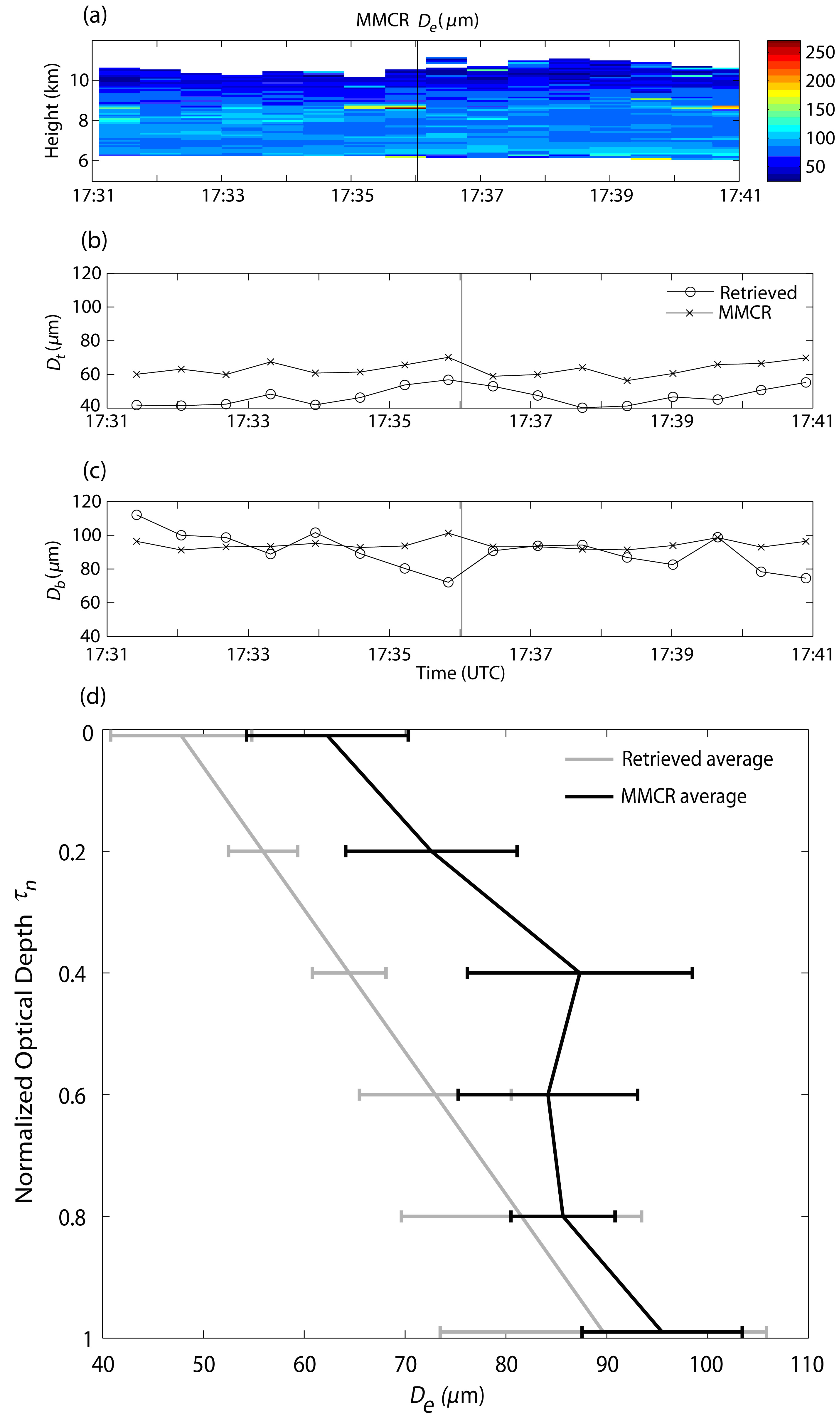
We have undertaken a difficult research task to develop a cirrus cloud vertical sizing program to infer simultaneously cloud-top and cloud-base effective sizes and optical depth using moderate-resolution imaging spectroradiometer (MODIS) 0.645, 1.64, 2.13, and 3.75 µm channels. Our approach followed a successive minimization method based on a look-up table library of pre-computed reflectances generated from an adding-doubling radiative transfer program with corrections for Rayleigh scattering at the 0.645 µm band, above-cloud water vapor absorption, and the 3.75 µm thermal emission effect. The retrieval algorithm was applied to three MODIS cirrus scenes over the ARM Climate Research Facility (ACRF) Southern Great Plains (SGP) site, North Central China, and Northeast Asia. The retrieved cloud optical depth and mean effective sizes from this approach compared reasonably well to the MODIS cloud products. Subsequently, the retrieved cloud-top and cloud-base ice crystal effective sizes were assessed by using collocated and coincident data from the ground-based millimeter wave cloud radar (MMCR), and the Cloud Profiling Radar (CloudSat). The retrieved cloud optical depth and the vertical profile of extinction coefficient were compared to those determined from the backscattering data of the Cloud-Aerosol Lidar with Orthogonal Polarization (CALIPSO). Differences between the passive and active retrievals for cloud properties are discussed in light of the assumptions made in collocation process and the limitations in radar/lidar cirrus cloud remote sensing capability.
Summary
Retrieved mean effective sizes are well correlated with radar-derived mean sizes, but are generally smaller in magnitude, because the radar beams tend to miss small cloud particles. Overall, the cirrus cloud vertical sizing retrieval algorithm represents a step of progress in the development of satellite cloud retrieval programs in terms of its capability to determine the vertical cloud particle size profile, and is potentially applicable to the processing of remote sensing data from the next generation Visible Infrared Imager Radiometer Suite/National Polar-orbiting Operational Environments Satellite System (VIIRS/NPOESS), which is to be launched beyond 2010.