Which grid spacing is sufficient for models to simulate organized storms under global warming?
Submitter
Prein, Andreas Franz — National Center for Atmospheric Research (NCAR)
Wang, Die — Brookhaven National Laboratory
Area of research
Cloud Processes
Journal Reference
Science
Mesoscale convective systems (MCSs) are thunderstorm complexes that organize to cover hundreds of kilometers over several hours and are prolific rain producers. Climate models have difficulties simulating MCSs well, for which the horizontal resolution of the model grid is a key factor affecting model performance. We assess the model resolution sufficient to simulate MCSs by systematically changing the grid spacing in simulations for the current climate and under global warming scenarios.
Impact
Mesoscale convective systems are a major contributor to the intensification of short-duration rainfall extremes with implications for flash flood risks. The results will guide climate model development and improve future climate predictions.
Summary
In recent years, climate models have been transitioning to convective-permitting scales (kilometer-scales) and significant improvements have been made in terms of reproducing bulk MCS properties (e.g., precipitation accumulation, propagation speed). However, large deficiencies persist in simulating small-scale processes (e.g., entrainment, updrafts) that are important to MCS evolution. Therefore, there is an urgent need both for understanding the convergence of MCS characteristics dependent on model grid spacing, and for understanding which model resolution is sufficient for simulating climate change impacts on MCSs.
We simulated a 10-member ensemble of idealized mid-latitude MCS under current and future climate conditions using the Weather Research and Forecasting (WRF) model. We studied the resolution sensitivity for three distinct atmospheric regimes: hydrostatic (resolution dx =12 km), kilometer-scale (dx = 4, 2, and 1 km), and large-eddy scale (dx = 500 m and 250 m). When enhancing model resolution from dx = 12 km to 4 km, the model results indicate a dramatic convergence in the simulation of MCS precipitation, propagation, cold pool, and cloud properties compared to dx = 250 m simulations. Continuing to refine dx to < 4 km results in improved small-scale processes such as up- and downdrafts and mass flux, but only in modest improvements in larger-scale features such as precipitation rate, cold pool depth and intensity, and anvil coverage. A much higher resolution of dx < 250 m is needed to represent downdraft size, intensity, and mass flux. Under global warming scenarios, models with dx = 4 km reliably capture most climate change signals of MCS bulk properties; however, significantly different climate change signals are found in dx = 12 km runs, which overestimate extreme precipitation changes by up to 100%.
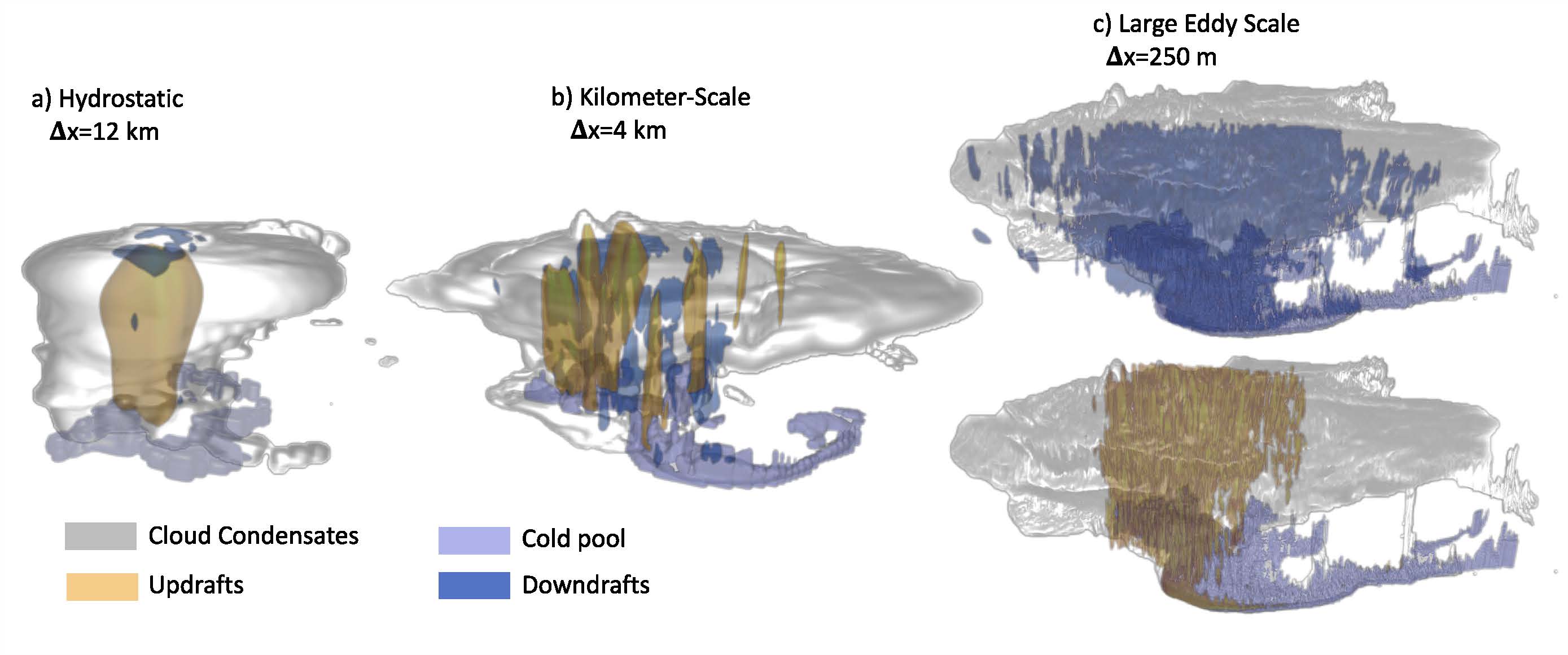
Figure 1. Features of an MCS under current climate conditions as simulated for different horizontal grid spacings: hydrostatic (a, dx = 12 km), non-hydrostatic kilometer-scale (b, dx = 4 km), and large-eddy scale (c, dx = 250 m). Shown are the cloud condensate (grey shading), cold pools (violet; −0.005 m s−2), updrafts (yellow; > 3 m s−1), and downdrafts (blue; > 1.5 m s−1). From journal.