High-resolution shallow cumulus cloud observations over north Alabama
Submitter
Zhang, Yunyan — Lawrence Livermore National Laboratory
Tian, Jingjing — Pacific Northwest National Laboratory
Area of research
Cloud Distributions/Characterizations
Journal Reference
Science
To constrain land surface energy budget and study convection triggering, it is critical to have continuous large-scale shallow cumulus (ShCu) observations. Such data are very limited, however, due to the existing instruments’ spatial coverage, resolution, and sensitivity. To address this issue, this study leverages ground-based ceilometer measurements by the University of Alabama at Huntsville in recent summers and introduces a robust validation framework to test the applicability of a newly developed satellite algorithm (Tian et al. 2021) in north Alabama (NA). This region has frequent ShCu occurrences and is in the vicinity of the new U.S. Department of Energy Atmospheric Radiation Measurement (ARM) user facility's third mobile facility (AMF3) deployment at Bankhead National Forest (BNF) in late 2024.
Impact
The newly developed ShCu detection algorithm and its regional validation framework using the ground-based ceilometer data significantly enhances our ability to study the ShCu morphology and the transition of these clouds to deep convection. The validation framework is easily repeatable, which enables straightforward validation across diverse regions where ceilometers are deployed. This advancement bridges observational gaps, supporting research on land-atmosphere interactions and aiding the improvement of kilometer-scale global storm-resolving models.
Summary
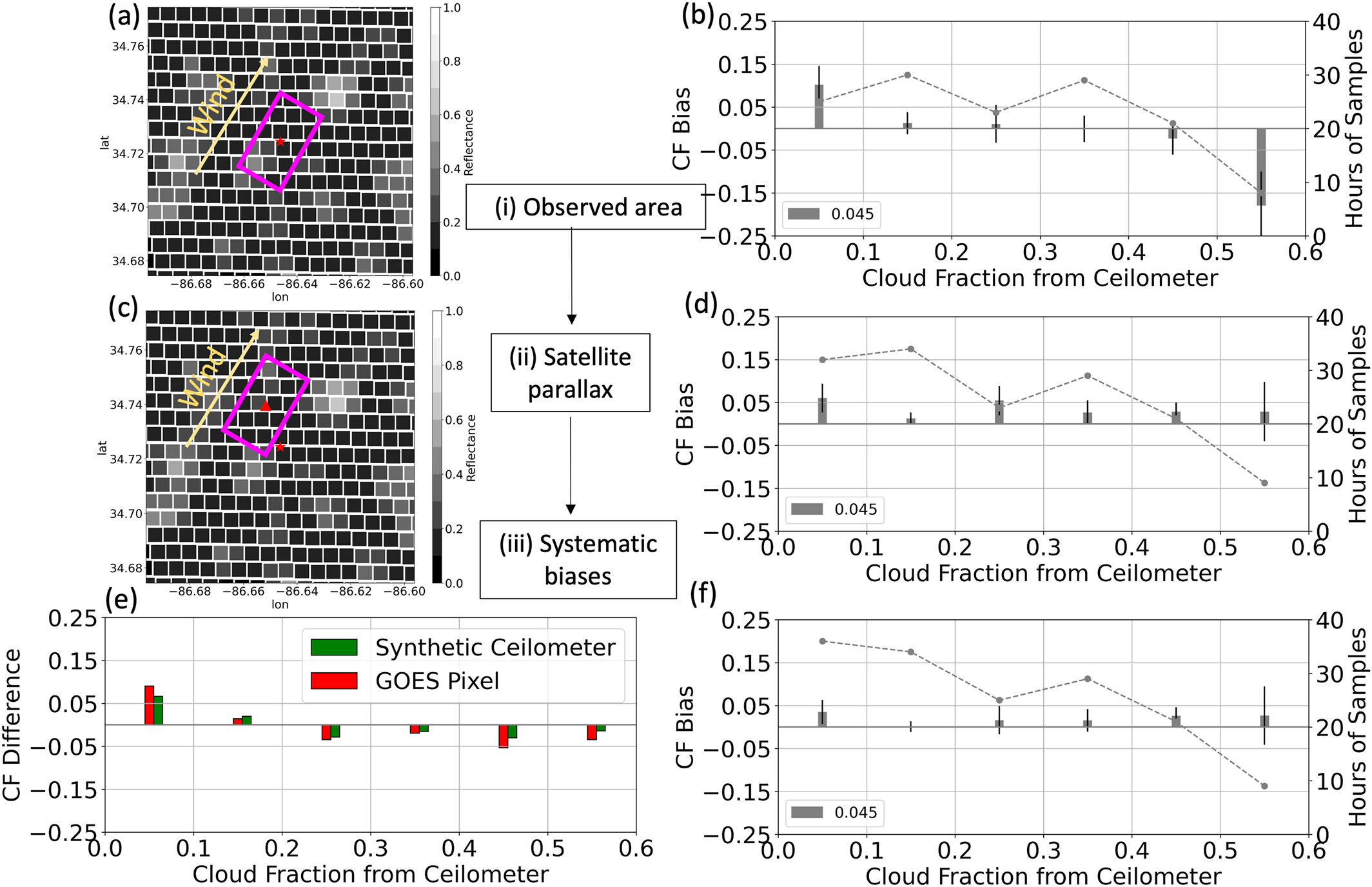
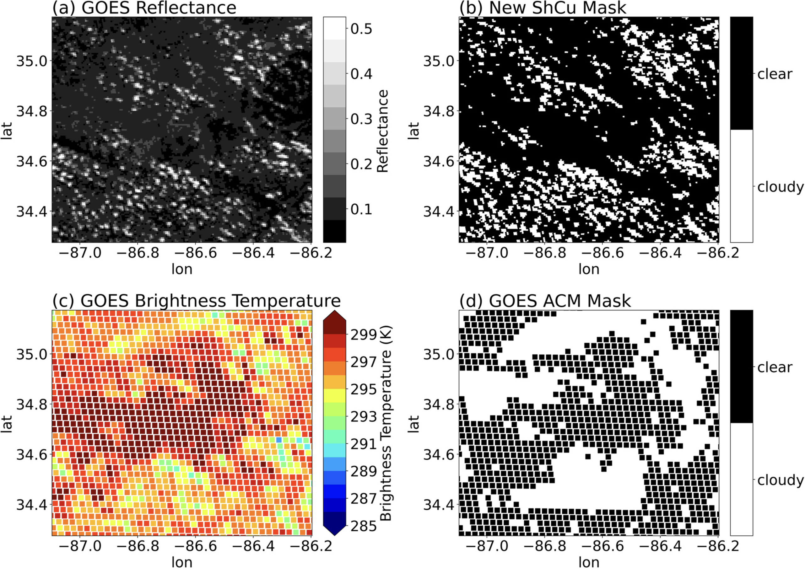
The detection of the low-level, sub-kilometer-scale, and short-lived ShCu during daytime is a missing feature in the current operational products of GOES satellites (Figure 2). A new satellite-based ShCu detection algorithm was originally developed using ground-based stereo-camera observations at the ARM Southern Great Plains (SGP) observatory (Tian et al. 2021; https://doi.org/10.3390/rs13122309). This study confirms the effectiveness of the new algorithm using ceilometer data (Figure 1) beyond its original development site and establishes a reflectance detection threshold (∆R) of 0.05 to accurately identify ShCu clouds in north Alabama. The reproducible validation framework can be used to assess the detection thresholds of ShCu in various regions with deployed ceilometers, accounting for key discrepancies such as differences in observed areas, satellite parallax, and instrument biases. The resulting data set can provide critical insights into ShCu cloud morphology, life cycle, and interactions with land surface conditions. It will also bridge localized ground-based observations at the ARM BNF site in north Alabama with large-scale satellite data and support an improved understanding of land-atmosphere-cloud processes critical for Earth system modeling.


