ARM observations help diagnosis and validation of newly released high-resolution versions of E3SM
Submitter
Zhang, Yunyan — Lawrence Livermore National Laboratory
Area of research
General Circulation and Single Column Models/Parameterizations
Journal Reference
Science
With the rapidly increasing resolution of global and regional model simulations, how can we best use high-resolution ground-based observations to quickly diagnose model physics and efficiently feed back on model improvement? These two papers offer good examples of using ARM data to improve understanding of model behaviors on clouds and precipitation processes and land-atmosphere interaction.
Impact
The U.S. Department of Energy (DOE)'s newly developed high-resolution modeling capabilities, e.g., Simple Cloud-Resolving E3SM Atmosphere Model (SCREAM, 3.25 km) and the North American (NA) Regionally Refined Model (NARRM) of E3SM version 2 (~25 km for atmosphere), not only significantly enhance the model’s computational efficiency but also the physical performances on clouds and precipitation at regional scales. These improvements bridge the gap between global models and ground-based observations and makes more feasible model diagnosis and validation using high-resolution ARM data. Improvement of regional model performance using ARM data is essential for understanding fine-scale physical processes and avoiding the worst impacts, such as extreme events.
Summary
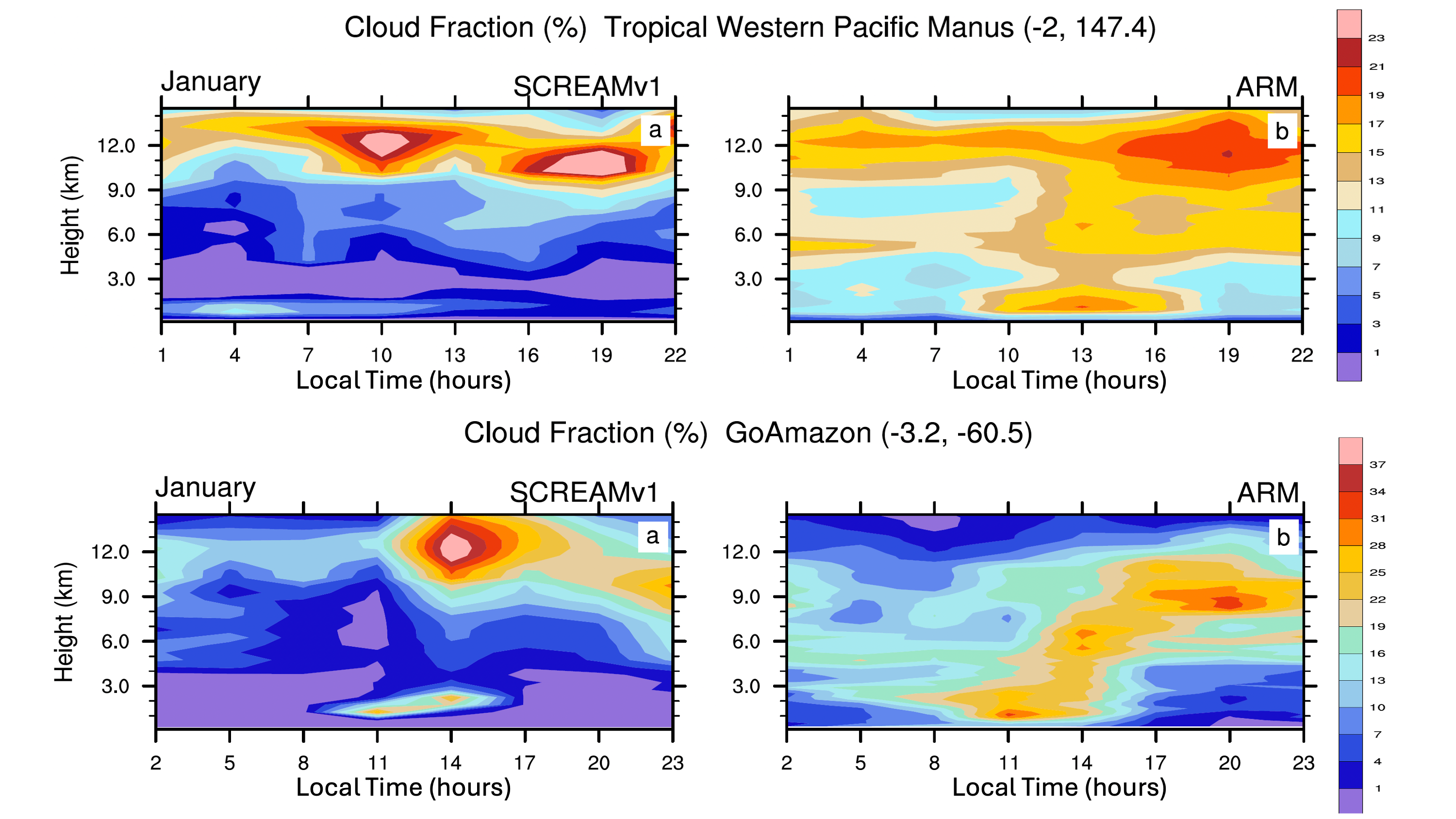
The new SCREAM model (EAMxx) introduced a complete rewrite of the E3SM atmosphere component in C++/Kokkos designed to run at km-scale resolution and is the first atmosphere model in the world to accomplish both exascale performance and >1 simulated-year-per-computational-day at 3-km resolution. This improved performance extended an earlier study at 3 km to include all four seasons, allowing the examination of diurnal cycles, and made it possible to validate simulation results against ground-based measurements like those made at ARM sites. ARM Best Estimates (ARMBE) of the radar/lidar observations and surface property measurements at seven ARM sites, including Southern Great Plains (SGP), Eastern North Atlantic (ENA), North Slope of Alaska (NSA), Tropical Western Pacific (TWP) C1/2/3, and GoAmazon, were used to diagnose daytime evolution of clouds, precipitation, precipitable water vapor, liquid water path, surface fluxes, temperature and humidity, etc. and quickly revealed that SCREAM produces reasonable boundary-layer cloud developments. However, this calculation lacks mid-level congestus in the tropics resulting from a drier lower-to-mid-troposphere. Surface windspeeds are often overestimated. Surface warm and dry biases still exist at land sites but are significantly improved.
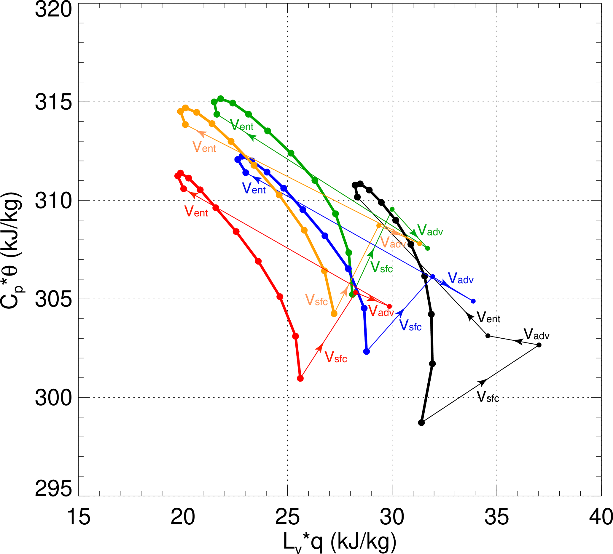
The NARRM was developed with the primary goal of more explicitly addressing DOE’s mission needs regarding impacts to the U.S. energy sector from Earth system changes. By design, the computational cost of E3SMv2 NARRM is only ~10-20% of a globally uniform high-resolution model at 25 km. During warm seasons at SGP, the surface conditions are warmer and dryer on the model-simulated clear-sky days than observed, with overestimation in both the planetary boundary-layer (PBL) height and the lifting condensation levels (LCL), while the shallow cumulus days in models result from a much moister environment than that in the observations.
These two studies showed that ARM data, especially those with a longer record and high temporal and spatial resolutions, are extremely useful in characterizing model’s fine-scale behaviors, providing insights on the direction of model improvements, and keeping tracks of the updated model physical performances.


