New data set supports international Year of Polar Prediction
Submitter
de Boer, Gijs — Brookhaven National Laboratory
Area of research
Atmospheric Thermodynamics and Vertical Structures
Journal Reference
Science
As part of the Year of Polar Prediction, unmanned aircraft, tethered balloons, and additional radiosondes were deployed at Oliktok Point, Alaska under the Profiling at Oliktok Point to Enhance YOPP Experiments (POPEYE) field campaign. These systems together provided greatly enhanced profiling of the lower atmosphere, including frequent measurements of thermodynamic and dynamic state, aerosol properties, and cloud properties.
Impact
The measurements collected during POPEYE are being used to evaluate and improve numerical modeling tools at a variety of scales. This includes evaluation of regional coupled models (NOAA CAFS model), operational weather forecasting models (NOAA HRRR, RAP), and eventually climate models and reanalyses. Additionally, these measurements are currently being used to improve our fundamental understanding of the vertical structure of turbulence and aerosol properties in the lower arctic atmosphere.
Summary
Between 1 July and 30 September 2018, small unmanned aircraft systems (sUAS), tethered balloon systems (TBS), and additional radiosondes were deployed at Oliktok Point, Alaska to measure the atmosphere in support of the second special observing period for the Year of Polar Prediction (YOPP). These measurements, collected as part of the “Profiling at Oliktok Point to Enhance YOPP Experiments” (POPEYE) campaign, targeted quantities related to enhancing our understanding of boundary-layer structure, cloud and aerosol properties, and surface-atmosphere exchange, and provide extra information for model evaluation and improvement work. Over the three-month campaign, a total of 59 DataHawk2 sUAS flights, 52 TBS flights, and 238 total radiosonde launches were completed as part of POPEYE. The data from these coordinated activities provide a comprehensive three-dimensional data set of the atmospheric state (air temperature, humidity, pressure, and wind), surface skin temperature, aerosol properties, and cloud microphysical information over Oliktok Point.
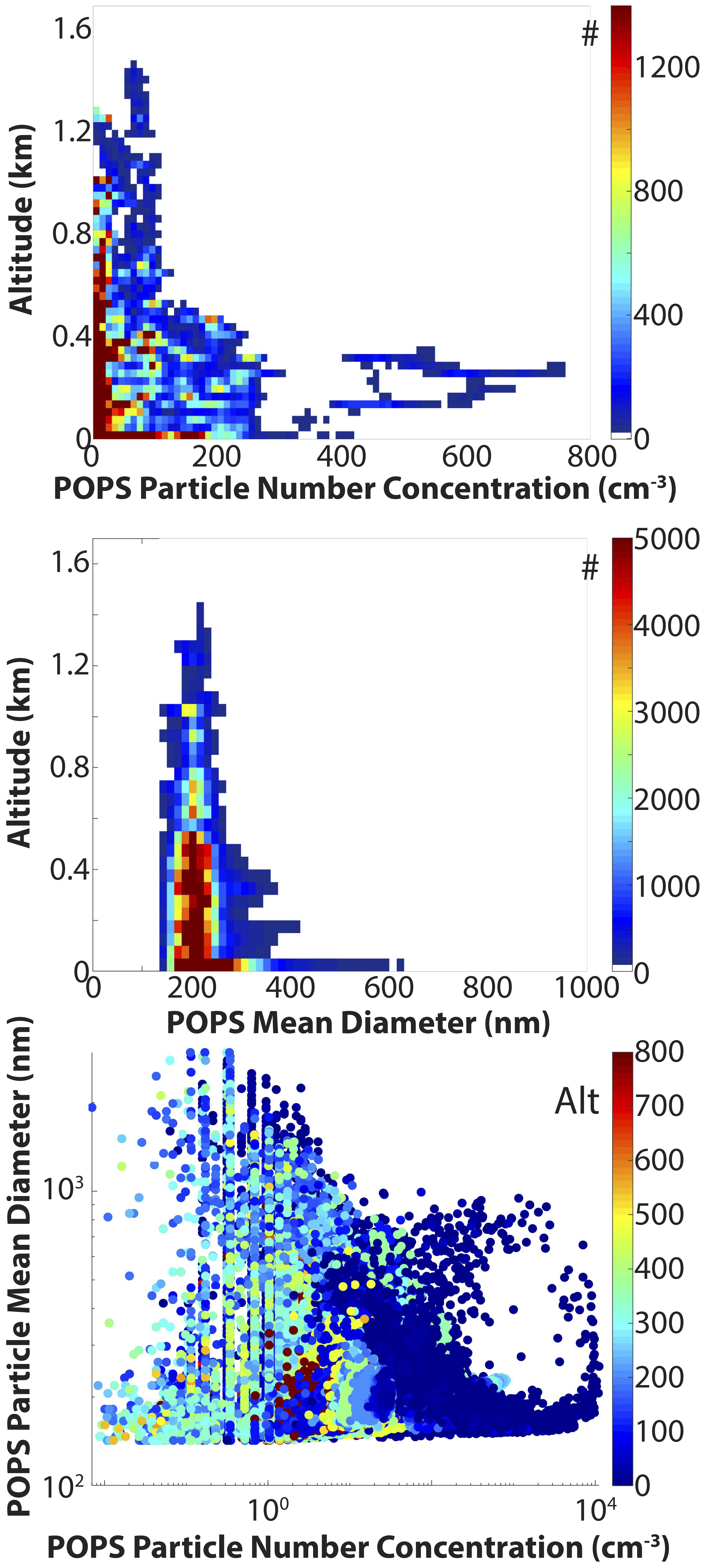
Figure 1. POPEYE aerosol statistics from the Printed Optical Particle Spectrometer. Included are (top to bottom): a two-dimensional histogram of particle number concentrations sampled as a function of height; a two-dimensional histogram of the particle size detected as a function of height; and a scatter plot showing the relationship between size and number, with colors representing altitude. From journal.