The TRACER campaign’s intensive operational period of measurements is underway and will cap a yearlong study
From June through September 2022, a focused field campaign investigating thunderstorms will unfold in Houston, Texas―thanks largely to funding from the U.S. Department of Energy (DOE).
In great numbers, scientists will be on hand for the planned intensive phase of an international, multi-agency field campaign called the TRacking Aerosol Convection interactions ExpeRiment (TRACER). The main field campaign began in October 2021.
DOE calls such a focused interval of study an “intensive operational period,” or IOP. That’s when a field campaign’s tempo increases and conditions for recording observations are optimal.
Thunderstorms, also called convective storms, proliferate during the summer months in Houston, a subtropical metropolis of 2.3 million.
During the TRACER IOP, scientists are running more than a dozen projects funded by DOE’s Atmospheric System Research (ASR) program.
Core instruments and major funding are provided by ASR’s sister program, the Atmospheric Radiation Measurement (ARM), a DOE Office of Science user facility.
In time, data from TRACER will improve storm forecasting and predictive climate models related to not just Houston but all the world’s vulnerable coastal cities.
“We fully expect there will be lots of convection for us to observe,” says TRACER lead scientist Michael Jensen, a meteorologist at DOE’s Brookhaven National Laboratory in New York.
Clouds and Aerosols
Thunderstorms are a big deal. They deliver needed rainfall across the world, but sometimes too much at once.
Scientists are still gathering data on how convective storms grow, pour rain, and generate lightning. During TRACER, one main research focus is on how the life cycles of storm clouds are affected by aerosols.
Aerosols are liquid and solid particles in the air. Some are from natural sources, like uplifted farm soils or sea spray; others are the result of human activity; and many combine a bit of both. Aerosols strongly impact clouds and precipitation.
During the TRACER IOP, DOE and its campaign partners will put additional instruments at ground sites. There will be instrumented boats, balloons, trucks, and research aircraft taking part too.
Campaign partner institutions number more than 30 universities; seven DOE national laboratories; one Texas state agency; and many federal agencies, including NASA, NOAA, and the National Science Foundation (NSF).
A timeline of related campaigns is available on ARM’s TRACER web page.
Cities in Focus
The aim of TRACER is to improve predictive models by collecting uniquely comprehensive data on convective storms over a year, at wide scales of time and space.
The aim is important to Earth and human ecosystems. Thunderstorms can wreak havoc on human lives and the built environment. It is better to know when they are coming, how strong they will be, and what feeds their intensity.
“Most people impacted by extreme events and climate change live in urban environments. We are learning important lessons about collecting measurements in the urban environment.”
– Michael Jensen
“Most people impacted by extreme events and climate change live in urban environments,” says Jensen, who sees TRACER as a precursor to DOE’s proposed urban weather laboratories. “We are learning important lessons about collecting measurements in the urban environment.”
Houston is an excellent place to study the effects of such extreme events on urban areas. Historically, the city is a hot spot for severe weather.
In 2017, for example, Hurricane Harvey hovered over Houston for four days. The storm swept in from the nearby Gulf of Mexico and dumped more than 60 inches of rain, a record for a major U.S. city. Water topped levees and trapped thousands in their homes.
Universities Step in With ASR Support
Many university scientists, postdoctoral researchers, graduate students, and technicians are headed to the TRACER IOP.
TRACER participants include 11 teams of university researchers funded by ASR. (Read the project descriptions on the ASR website.)
Ten received grants in 2020. The 11th, led by Alexander Laskin from Purdue University, received funding in 2021.
Laskin’s ASR project will investigate the physical and chemical properties of atmospheric particles collected during TRACER, with an emphasis on how they influence the water cycle.
During July, ASR-funded scientist Chris Cappa of the University of California, Davis, will direct TRACER-Carbonaceous Aerosols Thrust (TRACER-CAT). Carbonaceous aerosols predominate in polluted urban environments. These suspended particles include organic carbon and black carbon.
Cappa’s team will investigate how the optical, chemical, and physical properties of black-carbon aerosols affect cloud formation.
Closely allied to Cappa’s work is another TRACER-CAT campaign led by Allison C. Aiken and Manvendra Dubey of Los Alamos National Laboratory (LANL) in New Mexico. With ASR funding, TRACER-CAT-LANL will study how carbon-based aerosols take up water and their effects on light absorption.
ASR-funded scientist Gijs de Boer at the University of Colorado, Boulder, has a campaign that will add a unique observation platform during the TRACER IOP: uncrewed aerial systems. These small, low-flying aircraft can assess pre-convection conditions as well as observe atmospheric circulations on a regional scale.
For the entire IOP, Markus Petters of North Carolina State University will lead the TRACER-Particle Flux Measurements (TRACER-PFM) campaign. Supported by ASR, Petters’ team will use aerosol instrumentation to collect data on new atmospheric particles, including how they grow, age, and are removed from the atmosphere.
Mobile Laboratories
Alongside ARM radar in Pearland, Texas, a mobile laboratory from the University of Wisconsin, Madison, will operate as part of the TRACER-Coastal Urban Boundary-layer Interactions with Convection (TRACER-CUBIC) campaign.
Led by the University of Oklahoma’s Petra Klein, TRACER-CUBIC includes two additional mobile platforms stacked with Doppler wind lidars, thermodynamic profilers, and surface meteorological stations.
In her ASR-funded work, Klein hopes to enhance present data on how turbulence and aerosols in the boundary layer influence storms.
Through July and August, Rebecca Sheesley of Baylor University in Waco, Texas, will lead the TRACER-Mapping Aerosol Across Houston (TRACER-MAP) campaign.
Data from instrumented sites across Houston will measure the effect of urban pollution on thunderstorms. These data will also quantify how the city’s aerosol regimes change from place to place.
As part of the ASR TRACER-MAP project, Sheesley’s team will use a mobile air quality lab developed by researchers at Baylor and Rice universities and the University of Houston.
TRACER-MAP data sets will inform future DOE projects and improve models of how aerosols affect deep convection in urban systems.
During 30 days of the IOP, Anita Rapp of Texas A&M University will direct a campaign with ASR support to investigate aerosols and deep convection.
Twice daily, a trailer equipped with radiosondes, micropulse lidar, and aerosol-measuring gear will target convection triggered by sea-breeze fronts and maritime air masses.
Aerosol Evolution and Ultrafine Particles

Jian Wang studies the evolution of aerosols and their impacts on climate and air quality at Washington University in St. Louis, Missouri. In July and August, Wang’s ASR-funded IOP campaign will investigate the microphysics of aerosols, their effect on clouds, and how efficiently they take up water.
Starting July 1, Jim Smith of the University of California, Irvine, will unspool an ASR study of ultrafine aerosol particles.
These seed-like particles suspended in air can be as small as 4 nanometers wide. In the presence of pollutants, the properties of these water-condensation platforms can change, affecting cloud droplet formation.
Back at his Irvine lab, Smith’s group uses unique instruments to study particles captured in the field. One is the thermal desorption chemical ionization mass spectrometer, which identifies a particle’s chemical composition.
TRACER Modeling and Forecasting
Convective storm researcher and NASA consultant Susan van den Heever of Colorado State University helped pioneer the idea of a campaign such as TRACER, which investigates aerosol-convection interactions.
“A lot of our fundamental understanding of these interactions comes from her work,” says Jensen.
Backed by ASR, van den Heever will develop enhanced observational and modeling strategies to look at the microphysics of thunderstorms. She and her team will analyze TRACER lightning data and measurements from polarimetric radar.
Polarimetric data provide the orientation and shape of a radar signal.
Marcus van Lier-Walqui, an expert in Bayesian statistical methodologies at Columbia University, is moving in similar directions. His ASR project will analyze polarimetric radar and lightning data to create high-resolution simulations that support TRACER science goals.
His work will leverage rapid-scan data from polarimetric radars to examine storm dynamics in very fine detail.
In an unusual circumstance for modelers, van Lier-Walqui and others will use daily forecast simulations during the IOP to troubleshoot models in near-real time.
ARM at Work
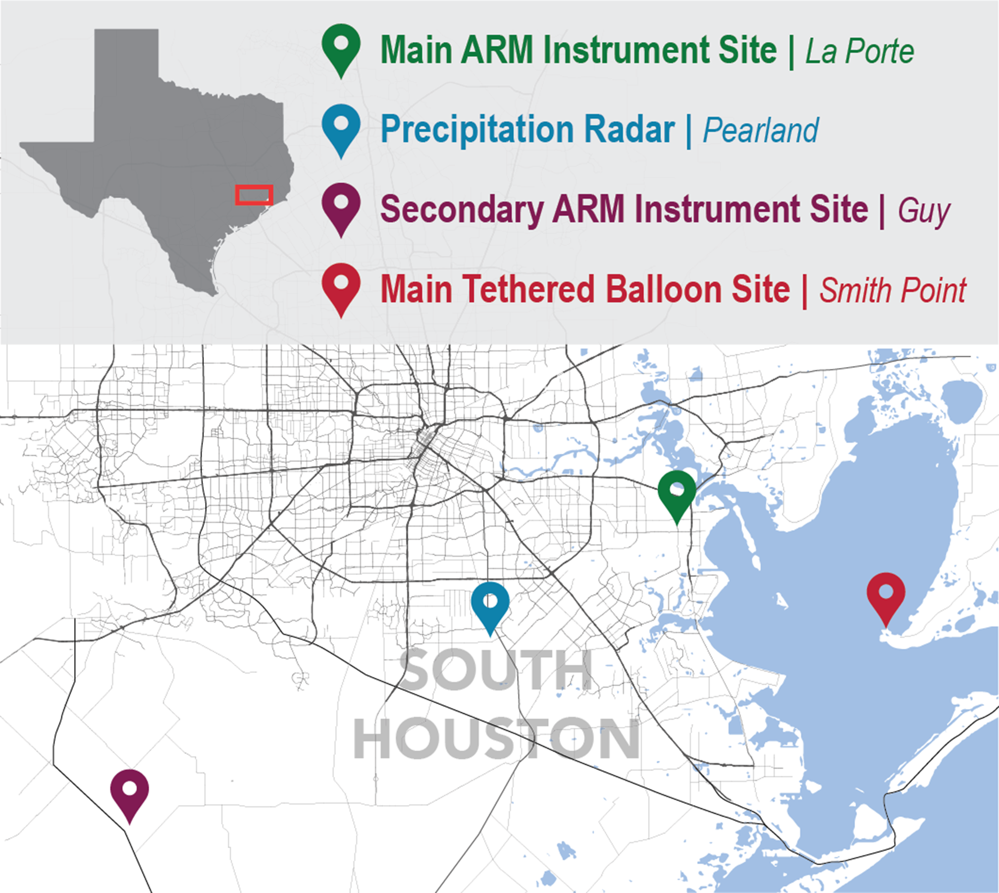
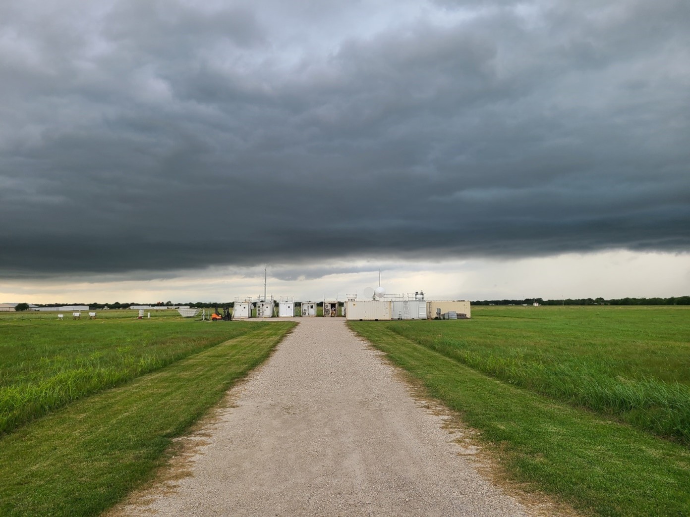
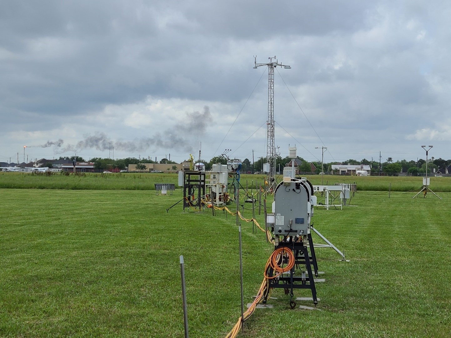
Two ARM TRACER instrument sites have operated since the campaign began.
The main ARM site in La Porte, Texas, is just southeast of Houston’s city center. Atmospheric conditions roughly mirror Houston’s eclectic mix of aerosols.
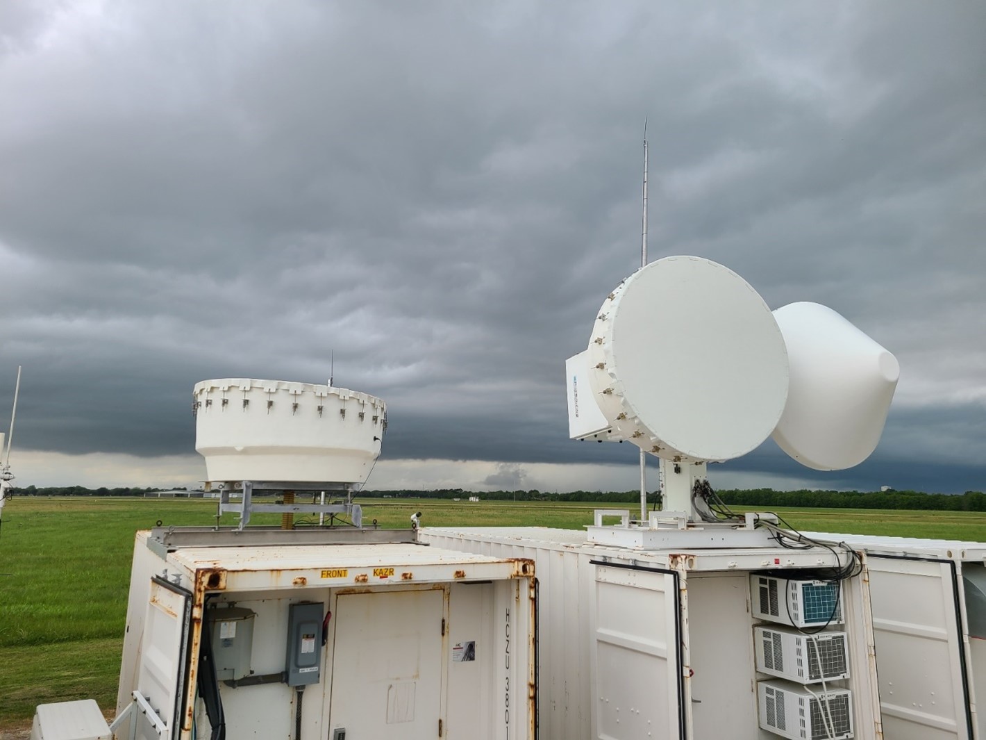
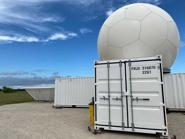
The instruments in La Porte are part of an ARM Mobile Facility, which also includes portable shelters and communications and data systems.
Southwest of the mobile facility in Pearland, Texas, is a C-Band Scanning ARM Precipitation Radar.
During the IOP, the radar will get a boost from a new software program that automates tracking single convective cells as they evolve to form mature storm systems.
Rural and Coastal Measures
Two other ARM sites will operate for the first time during the TRACER IOP.
For two weeks a month, rural Guy, Texas, will host instruments from guest scientists, ARM sensors, radiosonde (weather balloon) launches, and a tethered balloon system (TBS). The objective is to measure the background rural environment, including relatively clean aerosols from soil and sea sources.
In Guy, a four-month campaign on vertically resolved new-particle formation will unfold, with Brookhaven Lab scientist and TRACER science team member Chongai Kuang at the helm.
New nanoscale particles can grow large enough to become cloud condensation nuclei, which influence cloud formation and rain. Kuang’s instruments on the TBS platform will collect rare aerial measurements of such particles. The data will provide insights into boundary-layer development and the influence of sea breezes on cloud formation.
The boundary layer is the lowest part of the troposphere, which is directly and quickly influenced by surface conditions.
In Smith Point, Texas, on the eastern shore of Galveston Bay, additional TBS operations will take place for one week each month, overlapping with the TBS measurements at Guy. These measurements will provide important details on the characteristics of the low-level circulations associated with Galveston Bay, including local aerosol conditions.
Other Agencies at Work
“TRACER is a huge collaborative effort―and not just across DOE offices,” says Jensen.
During the IOP, NASA will begin a second phase of its TRACER-AQ (Air Quality) experiment. The first phase took place in fall 2021.
In addition, NSF plans some field campaigns that are coordinated with the TRACER IOP.
One is a large effort called the Experiment of Sea Breeze Convection, Aerosols, Precipitation and Environment (ESCAPE). Its airborne and ground-based components will operate from May 30 to June 30.
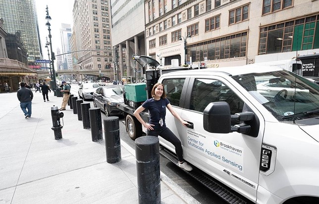
ESCAPE’s lead scientist is remote sensing expert Pavlos Kollias, who has a joint appointment at Brookhaven Lab and Stony Brook University in New York. He is also the chief scientist of the lab’s Center for Multiscale Applied Sensing (CMAS).
ESCAPE will enlist the use of mobile observatories on wheels, with X-band radars from the University of Oklahoma and Stony Brook.
CMAS will deploy a Doppler lidar truck first used in the summer 2021 in Manhattan to study airflow around skyscrapers. In Houston, this mobile observatory will, among other things, study variations in temperature and rainfall between Houston’s city center and its suburbs.
In addition, Colorado State University will provide a C-band radar for ESCAPE.
Another NSF-funded project is the Convective cloud Urban Boundary-layer Experiment (CUBE). Researchers are interested in the influence of the urban environment on convection and precipitation. They will deploy flux towers; a scintillometer, which measures fluctuations in turbulence; a Raman lidar; and an extended meteorology network.
CUBE is led by Prathap Ramamurthy and Jorge Gonzalez from the City College of New York.
Gonzalez led a 2021 paper on the grand challenges of urban climate resiliency, with Ramamurthy as a co-author.
Data at Hand, Data to Come
Even before the IOP, TRACER already generated a large amount of useful, freely available ARM data. There are unique data on the chemical composition of Houston aerosols, for instance.
ARM data are typically available in the ARM Data Center a day or so after they are collected.
Value-added products will follow shortly as they are processed. These are higher-order data products that have gone through extra layers of ARM processing and analysis to make certain data easier to use.
Principal investigators participating in TRACER are required to make measurements available within six months of the campaign’s end.
Other agencies and non-ARM TRACER principal investigators, says Jensen, “have their own data delivery policies and time scales.”
Through TRACER, “we are getting a diversity of observations,” he says. “They will inform our understanding of how detailed atmospheric characteristics affect the weather—and ultimately Earth’s climate and people’s lives.”
# # #Author: Corydon Ireland, Science Writer, Pacific Northwest National Laboratory
This work was supported by the U.S. Department of Energy’s Office of Science, through the Biological and Environmental Research program as part of the Atmospheric System Research program.