![]() The 2023 American Meteorological Society (AMS) Annual Meeting will be held from January 8 to 12 in Denver, Colorado, as well as online. We want to make it easy for you to find ASR-relevant science, meet up with colleagues, and discover new connections during the event.
The 2023 American Meteorological Society (AMS) Annual Meeting will be held from January 8 to 12 in Denver, Colorado, as well as online. We want to make it easy for you to find ASR-relevant science, meet up with colleagues, and discover new connections during the event.
Below is a list of ASR-related AMS meeting highlights (all times Mountain). Information is subject to change; please check the AMS Annual Meeting website for the most up-to-date information.
Follow us on Twitter (@armnewsteam) and Facebook (@arm.gov) for a real-time guide to relevant activities using the hashtags #ARMAMS and #AMS2023.
Go here to find more sessions, talks, and posters related to Atmospheric System Research (ASR) as well as ARM-related presentations and posters.
Add your presentation to be featured on the ASR or ARM presentation web pages.
Attending AMS in person? U.S. Department of Energy ASR Program Manager Shaima Nasiri will be presenting an ASR program poster in the AMS poster hall on January 10. Also, make sure to visit the ARM booth in the exhibition hall—Booth 516. There you can view facility materials, attend flash talks, and meet with ARM and ASR representatives.
Check out:
Invited Presentations
- 5B.3: An Overview of TRACER-AQ in Houston. James Flynn, University of Houston.
Tuesday, January 10, 8:30–10 a.m., Colorado Convention Center – 205 (Meeting Room Level)
- 7A.5: On the Effects of Immersion-Freezing Ice-Nucleating Particles on Deep Convection. Sonia Lasher-Trapp, University of Illinois at Urbana-Champaign.
Tuesday, January 10, 1:30–3 p.m., Colorado Convention Center – 203 (Meeting Room Level)
- 13B.2: New insights into marine aerosols over the midlatitude and Arctic oceans. Jian Wang, Washington University in St. Louis.
Thursday, January 12, 8:30–10 a.m., Colorado Convention Center – 207 (Meeting Room Level)
Featured Field Campaign Presentations
Surface Atmosphere Integrated Field Laboratory (SAIL)
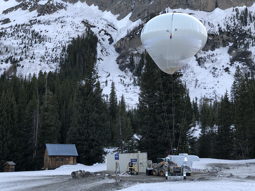
The SAIL field campaign, which kicked off in September 2021 and is set to close operations in June 2023, takes place in the 300-square-kilometer (116-square-mile) East River Watershed near Crested Butte, Colorado. As part of SAIL, a portable ARM observatory is providing valuable atmospheric data that researchers are using to develop detailed measurements of mountainous water-cycle processes as they pertain to the Colorado River, which supplies water for 40 million people in the American West.
Through SAIL, researchers from DOE national laboratories, universities, and research centers and agencies will enable an atmosphere-through-bedrock understanding of mountainous water cycles. NOAA and the National Science Foundation are sponsoring concurrent field studies in the region that will contribute to SAIL research.
- ORAL SESSION—2B: The ABL over Heterogeneous Terrain I
Monday, January 9, 10:45 a.m.–noon, Colorado Convention Center – 504 (Meeting Room Level)
Reported SAIL presentation:- 2B.5: The Atmospheric Boundary Layer in the East River Valley in the Colorado Rocky Mountains during the Seasonal Snow-Cover Change. Bianca Adler, Cooperative Institute for Research in Environmental Sciences.
- ORAL SESSION—3: Results from Recent Field Projects
Monday, January 9, 1:30–3 p.m., Colorado Convention Center – 705/707 (Meeting Room Level)
Reported SAIL presentation:- 3.2: Synergy between SPLASH and SAIL Program Radar Observations. V. Chandrasekar, Colorado State University.
- ORAL SESSION—Joint Session 7B: Hydrometeorology in High-Altitude Complex Terrain: Multi-Scale Observations and Models to Advance Understanding and Future Changes II
Chaired by SAIL lead scientist Daniel Feldman, Lawrence Berkeley National Laboratory
Tuesday, January 10, 1:30–3 p.m., Colorado Convention Center – 405 (Meeting Room Level)
Reported SAIL presentations:- Joint7B.5: X-Band Precipitation Estimates for the SAIL Field Experiment. Joseph Robert O’Brien, Argonne National Laboratory.
- Joint7B.6: From Snowflake to Snowpack: How do Cloud Microphysical Representations Influence Hydrologic Response? Alejandro N. Flores, Boise State University.
Tracking Aerosol Convection interactions ExpeRiment (TRACER)
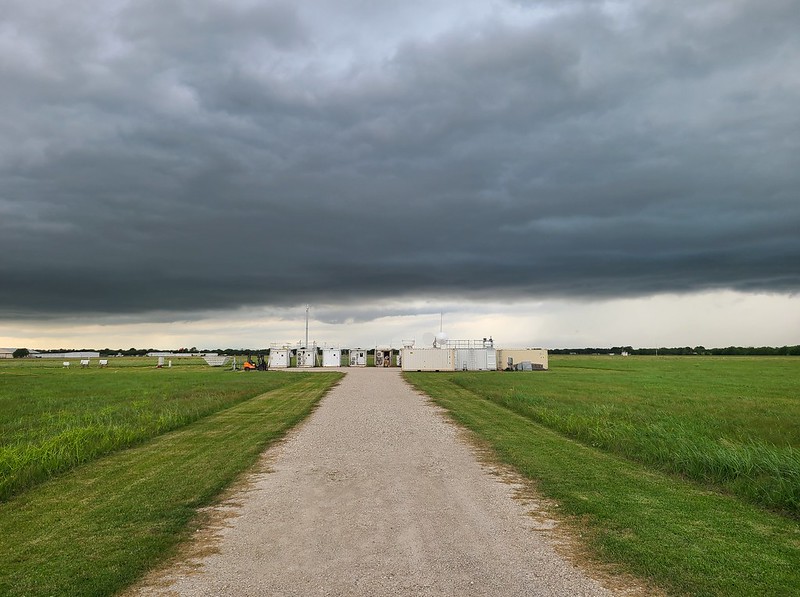
TRACER, which ran from October 2021 through September 2022, provided convective cloud observations with high space and time resolution over a broad range of environmental and aerosol conditions around the Houston, Texas, region. As part of TRACER, ARM deployed a portable observatory southeast of downtown Houston, a scanning precipitation radar south of downtown, and an ancillary site southwest of the city, where tethered balloon systems were launched. Together, these ARM measurements are helping researchers better understand the variability of aerosols and meteorology between the urban Houston area and surrounding rural environments.
- POSTER SESSION—Mesoscale Meteorology
Sunday, January 8, 6:30–8:30 p.m., Colorado Convention Center – Hall A (Exhibit Hall Level)
Reported TRACER presentations:- S181: Examining Sea-Breeze Characteristics in the Houston, TX Region. Emily Cristina Melvin, Brookhaven National Laboratory.
- S182: Analyzing Properties of Outflow Boundaries Relating to Sea Breeze Convection. Peyton Dale Langford, Texas A&M University.
- S183: CSAPR Radar Cell Tracking Performance & Airmass Effect on Storms During TRACER. Brandon Tomerlin, Texas A&M University.
- S184: Cataloging Parent Airmass of Convective Cells During Enhanced Operations of TRACER. Cole Hood, Texas A&M University.
- ORAL SESSION—2B: The ABL over Heterogeneous Terrain I
Monday, January 9, 10:45 a.m.–noon, Colorado Convention Center – 504 (Meeting Room Level)
Reported TRACER presentation:- 2B.2A: Investigating Sea Breeze Impacts on the Atmospheric Boundary Layer Using UAS Observations from the TRACER Campaign. Francesca Maria Lappin, Cooperative Institute for Severe and High-Impact Weather Research and Operations/University of Oklahoma.
- ORAL SESSION—3: Lidar Measurements and Studies from Focused Field Campaigns I
Monday, January 9, 1:30–3 p.m., Colorado Convention Center – 702 (Meeting Room Level)
Reported TRACER presentation:- 3.2: Lidar, Ozonesonde, and Satellite Intercomparisons during Tracer-AQ. Samuel Flusche, St. Edward’s University.
- ORAL SESSION—3A: Boundary Layer Flow and Turbulence over Urban Terrain II
Monday, January 9, 1:30–3 p.m., Colorado Convention Center – 502 (Meeting Room Level)
Reported TRACER presentation:- 3A.2: Boundary-Layer Profile Observations During the TRACER-CUBIC Campaign in Houston. Petra M. Klein, University of Oklahoma.
- POSTER SESSION—The ABL over Heterogeneous Terrain
Monday, January 9, 5–6:30 p.m., Colorado Convention Center – Hall A (Exhibit Hall Level)
Reported TRACER presentation:- 121: Sea-Breeze Boundary Layers Across Houston During the TRACER-CUBIC Campaign. Michelle Rose Spencer, Cooperative Institute for Severe and High-Impact Weather Research and Operations.
- POSTER SESSION—Results from Recent Field Projects Posters
Monday, January 9, 5–6:30 p.m., Colorado Convention Center – Hall A (Exhibit Hall Level)
Reported TRACER presentation:- 129: ARM Radar Data Quality and Data Characteristics of the TRACER Field Experiments. Ya-Chien Feng, Pacific Northwest National Laboratory.
- ORAL SESSION—5B: The Role of the Forecaster in an Era of Increased Idss, Probabilistic Tools and Uncertainty Information
Tuesday, January 10, 8:30–10 a.m., Colorado Convention Center – 601 (Meeting Room Level)
Reported TRACER presentation:- 5B.4: The NWS’s Support of the TRACER Field Campaign: A Decision Support Services and Data/Science Sharing Success. Lance Wood, National Weather Service.
- ORAL SESSION—5B: Regional Air Quality IV
Tuesday, January 10, 8:30–10 a.m., Colorado Convention Center – 205 (Meeting Room Level)
Reported TRACER presentation:- 5B.3: An Overview of TRACER-AQ in Houston (Invited Presentation). James Flynn, University of Houston.
- ORAL SESSION—7A: Greenhouse Gases II
Tuesday, January 10, 1:30–3 p.m., Colorado Convention Center – 103/105 (Meeting Room Level)
Reported TRACER presentation:- 7A.4: Urban and Industrial Carbon-Based Pollutant Monitoring Using EM27/SUNs in Houston, Texas During the Summer 2022 GeoCarb-TRACER Campaign. Elizabeth Spicer, University of Oklahoma.
- ORAL SESSION—7: Integrating Unmanned Aerial Systems (UAS) into Meteorology
Tuesday, January 10, 1:30–3 p.m., Colorado Convention Center – 705/707 (Meeting Room Level)
Reported TRACER presentation:- 7.3: CopterSonde Weather UAS: Updates on Recent OU CIWRO Developments. Antonio R. Ricardo Segales, Cooperative Institute for Severe and High-Impact Weather Research and Operations.
- ORAL SESSION—8A: Aerosol-Cloud Interactions in Deep Convective Clouds III
Co-chairs include TRACER lead scientist Michael P. Jensen
Tuesday, January 10, 3:45–5 p.m., Colorado Convention Center – 203 (Meeting Room Level)
Reported TRACER presentations:- 8A.1: Environmental Controls on Deep Convection Life Cycle in the Houston, Texas Region. Díe Wang, Brookhaven National Laboratory.
- 8A.3: Thermodynamic Variability across Sea-Breeze Fronts and Thunderstorm Updraft Characteristics during the TAMU TRACER Field Campaign. Milind Sharma, Texas A&M University.
- 8A.4: Aerosol Impact on Simulated Life Cycles of Isolated Deep Convection during the TRACER Field Campaign: Initial Sensitivity Experiment. Toshi Matsui, NASA Goddard Space Flight Center/University of Maryland.
- 8A.5: Joint Variability of Aerosol, Clouds, and Synoptic Meteorology over Southeastern Texas. Jungmin Minnie Park, Brookhaven National Laboratory.
- POSTER SESSION—Aerosol-Cloud Interactions in Deep Convective Clouds Posters
Tuesday, January 10, 5–6:30 p.m., Colorado Convention Center – Hall A (Exhibit Hall Level)
Reported TRACER presentations:- 544: Validation of NASA Unified WRF simulations of seabreeze convection sampled during the TRACER experiment with the Earth Model Column Collaboratory (EMC²). Robert C. Jackson, Argonne National Laboratory.
- 546: Summary of Convection and Aerosol Observations during the TRACER Intensive Operational Period. Michael P. Jensen, Brookhaven National Laboratory.
- POSTER SESSION—Posters for 12th Symposium on Lidar Atmospheric Applications
Tuesday, January 10, 5–6:30 p.m., Colorado Convention Center – Hall A (Exhibit Hall Level)
Reported TRACER presentation:- 592: Improvements in Characterizing Coastal Air Quality Science with Ground-Based and Airborne Profilers: Case Studies within Houston, TX. John T. Sullivan, NASA Goddard Space Flight Center.
- POSTER SESSION—11: Lightning Posters
Tuesday, January 10, 5–6:30 p.m., Colorado Convention Center – Hall A (Exhibit Hall Level)
Reported TRACER presentation:- 606: TRACER-MAP: A Preliminary Look at the Changes in the VOC Composition and Aerosol Optical Properties Before and After Precipitation Events in Houston. Kimberly Ann Sauceda, Baylor University.
- POSTER SESSION—25: AtChem Poster Session 1
Tuesday, January 10, 5–6:30 p.m., Colorado Convention Center – Hall A (Exhibit Hall Level)
Reported TRACER presentation:
- VIRTUAL POSTER SESSION—25: AtChem Virtual Posters
Tuesday, January 10, 6–7 p.m., virtual
Reported TRACER presentation:- V51: An Evaluation of Lidar Derived Ozone Curtain Profiles from the TRACER-AQ Campaign and WRF-Chem Simulation. Claudia Marie Bernier, University of Houston.
- ORAL SESSION—10C: Air Pollution Modeling, Forecasting, Attribution and Reanalysis at the Global and Regional Scales II
Wednesday, January 11, 10:45 a.m.–noon, Colorado Convention Center – 103/105 (Meeting Room Level)
Reported TRACER presentation:
- ORAL SESSION—14A: Intercomparison, Calibration, and Uncertainties of Instruments II
Thursday, January 12, 10:45 a.m.–noon, Colorado Convention Center – 702 (Meeting Room Level)
Reported TRACER presentation:- 14A.3: Calibration Procedure for Radar Wind Profilers during TRACER and inter-comparisons for KAZR and CSAPR Calibration Verification. Christopher R. Williams, University of Colorado Boulder.
- ORAL SESSION—14B: Remote Sensing of the Atmosphere III
Thursday, January 12, 10:45 a.m.–noon, Colorado Convention Center – 705/707 (Meeting Room Level)
Reported TRACER presentation:- 14B.4: Characterization of the Planetary Boundary Layer (PBL) in Houston, TX Using Trace Gas Profiles and Traditional Measurement Techniques. Alexander E. Kotsakis, NASA Goddard Space Flight Center/ERT Inc.
- ORAL SESSION—15A: Environmental Justice and Air Quality
Thursday, January 12, 1:30–3 p.m., Colorado Convention Center – 103/105 (Meeting Room Level)
Reported TRACER presentation:
Multidisciplinary Drifting Observatory for the Study of Arctic Climate (MOSAiC)
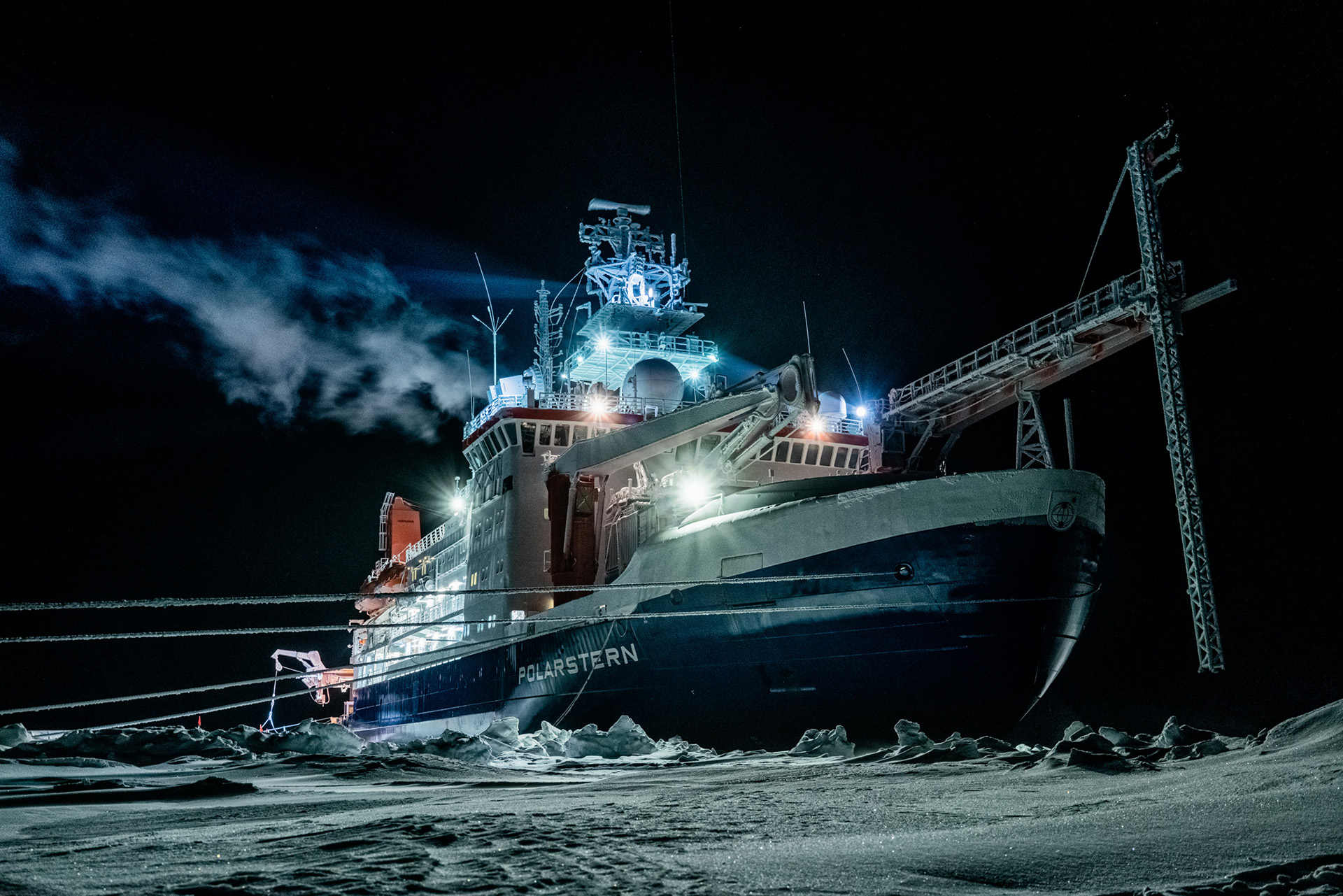
The massive MOSAiC expedition set out to document the atmosphere, sea ice, ocean, biogeochemistry, and ecosystem in the central Arctic. More than 400 field participants and 60 institutions from 20 countries were active in the German-led expedition from September 2019 to October 2020.
MOSAiC’s central observatory was the icebreaker R/V Polarstern, which froze into and then drifted with the arctic sea ice for most of the year. ARM provided the most atmospheric instruments—more than 50—to the expedition.
- ORAL SESSION—6: High-Latitude Air-Sea Interaction, Including Air-Sea-Ice Coupling
Tuesday, January 10, 10:45 a.m.–noon, Colorado Convention Center – 403 (Meeting Room Level)
Reported MOSAiC presentations:- 6.1: Dynamic Air-Sea-Ice Interactions at MOSAiC. Ola Persson, University of Colorado.
- 6.2: Characterization of Arctic Sea Spray Aerosol Particles from the Year-Long MOSAiC Expedition. Jessica Mirrielees, University of Michigan.
- ORAL SESSION—8: Scoping Boundary-Layers in the Dark and Cold Arctic Conditions Field Experiments and First Results
Tuesday, January 10, 3:45–5 p.m., Colorado Convention Center – 705/707 (Meeting Room Level)
Reported MOSAiC presentation:- 8.2: Observations of Wintertime Structure and Mixing Processes from an Instrumentation Suite at MOSAiC. Ola Persson, University of Colorado.
- VIRTUAL POSTER SESSION—24BLT: Virtual Posters
Tuesday, January 10, 6–7 p.m., virtual
Reported MOSAiC presentation:- V52: Turbulence in the Arctic Atmospheric Boundary Layer during Polar Night – Hot-Wire Observations with a Tethered Balloon during MOSAiC. Elisa F. Akansu, Leibniz Institute for Tropospheric Research.
- ORAL SESSION—9B: Atmospheric Ice-Nucleating Particles and Ice Formation Processes in Clouds I
Wednesday, January 11, 8:30–10 a.m., Colorado Convention Center – 207 (Meeting Room Level)
Reported MOSAiC presentation:- 9B.2: Closing the Gap on Understudied Aerosol-Climate Processes in the Rapidly Changing Central Arctic. Jessie Creamean, Colorado State University.
- ORAL SESSION—13B: Measurement and Modeling of Atmospheric Cloud Condensation Nuclei and Related Chemistry
Thursday, January 12, 8:30–10 a.m., Colorado Convention Center – 207 (Meeting Room Level)
Reported MOSAiC presentation:- 13B.2: New insights into marine aerosols over the midlatitude and Arctic oceans (Invited Presentation). Jian Wang, Washington University in St. Louis.
- ORAL SESSION—16B: The Stable and Polar Boundary Layers III
Thursday, January 12, 3:45–5 p.m., Colorado Convention Center – 504 (Meeting Room Level)
Reported MOSAiC presentation:- 16B.1: Boundary-Layer Processes over Sea Ice in Observations and Modeled with an Atmospheric-Ocean Single-Column Model (AOSCM). Gunilla Svensson, Stockholm University.
Cloud, Aerosol, and Complex Terrain Interactions (CACTI)
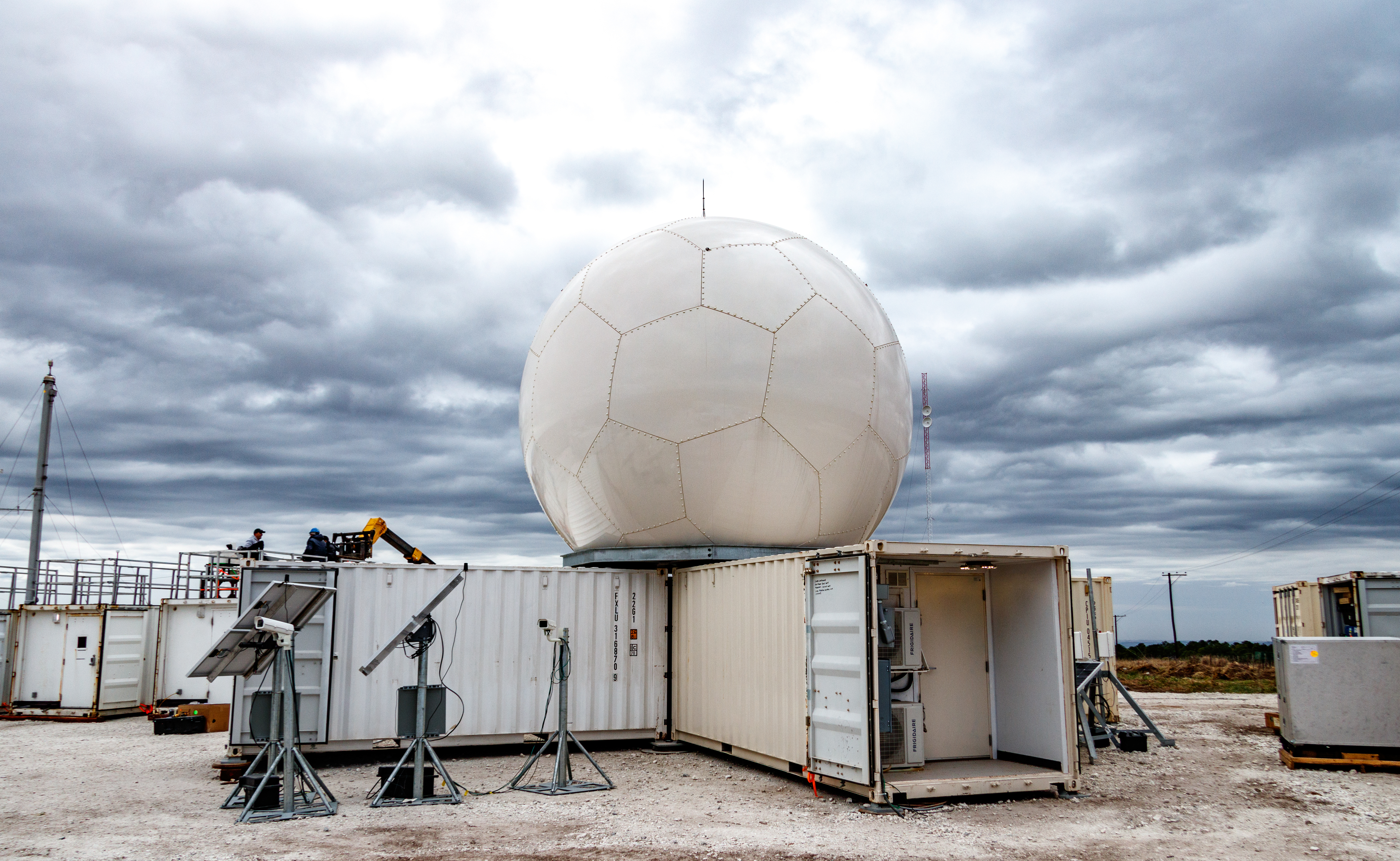
From October 2018 through April 2019, CACTI collected ground and aerial data to explore the life cycles of convective clouds in Argentina’s Sierras de Córdoba mountain range. This area is said to spawn the biggest thunderstorms in the world. The campaign featured the first deployment of the second-generation C-Band Scanning ARM Precipitation Radar, which delivers slice-like flat images of the atmosphere.
CACTI ran concurrently with Remote sensing of Electrification, Lightning, And Mesoscale/microscale Processes with Adaptive Ground Observations (RELAMPAGO), a campaign largely funded by the National Science Foundation.
- POSTER SESSION—Poster Session I
Monday, January 9, 5–6:30p.m., Colorado Convention Center – Hall A (Exhibit Hall Level)
Reported CACTI presentation:- 315: How Terrain Influences the Electrical Characteristics of Storms Observed during RELAMPAGO. Marquette N. Rocque, Colorado State University.
- ORAL SESSION—6: Advances in Cumulus Convection Measurements, Parameterization, and Modeling
Tuesday, January 10, 10:45 a.m.–noon, Colorado Convention Center – 704/706 (Meeting Room Level)
Reported CACTI presentation:- 6.5: Differing Controls on Convective Cell Deepening and Precipitation Intensity Based on Cell Width. Adam Varble, Pacific Northwest National Laboratory.
- ORAL SESSION—7A: Aerosol-Cloud Interactions in Deep Convective Clouds II
Tuesday, January 10, 1:30–3 p.m., Colorado Convention Center – 203 (Meeting Room Level)
Reported CACTI presentation:- 7A.5: On the Effects of Immersion-Freezing Ice-Nucleating Particles on Deep Convection (Invited Presentation). Sonia Lasher-Trapp, University of Illinois at Urbana-Champaign.
- POSTER SESSION—Poster Session II
Tuesday, January 10, 5–6:30 p.m., Colorado Convention Center – Hall A (Exhibit Hall Level)
Reported CACTI presentations:- 689: Updraft Dynamics in Deepening Cumuliform Convection during CACTI. Daniel Bazemore, Naval Postgraduate School.
- 690: Environmental Influences on the Width of Growing Convective Clouds Observed during the CACTI Campaign. James N. Marquis, Pacific Northwest National Laboratory.
- 694: Environmental Impacts on Simulated Deep Convective Cloud Growth during CACTI: Sensitivity to Model Resolution. Zhe Feng, Pacific Northwest National Laboratory.
- POSTER SESSION—3: MESO Tuesday ePosters
Tuesday, January 10, 5–6:30 p.m., Colorado Convention Center – Hall A (Exhibit Hall Level)
Reported CACTI presentation:- E32-2.8: Convective Population and Environments in Convection-Allowing Regional Climate Simulations over South America. Daniel Sebastian Veloso-Aguila, Colorado State University.
This work was supported by the U.S. Department of Energy’s Office of Science, through the Biological and Environmental Research program as part of the Atmospheric System Research program.