Growing up in Eritrea, Hagos witnessed the worst droughts, and years later worked to explain what caused them

As a boy, Samson Hagos trekked miles with his brothers to draw drinking water from deep wells once intended for irrigation outside Asmara, the capital city of Eritrea. On the way back home, his share sloshed in a yellow plastic container that weighed 11 pounds; at age 5, Hagos weighed about 40.
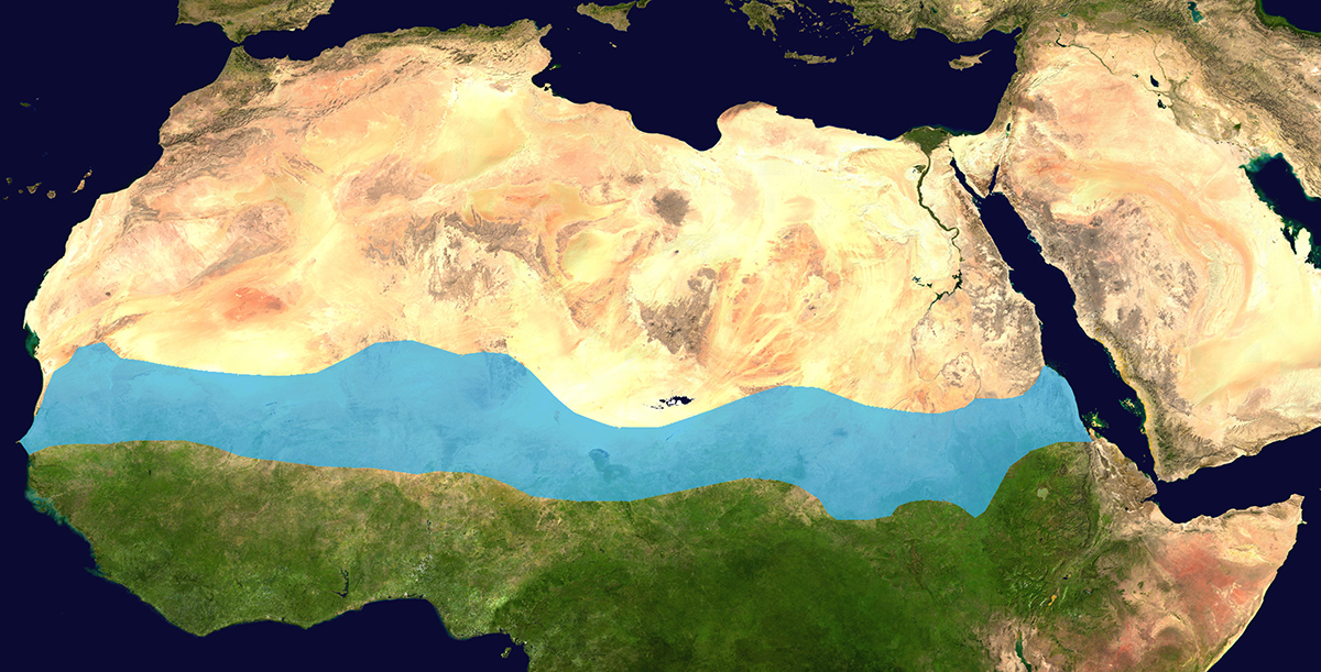
The dire occasion for those treks, in 1985, was the deepest point of an epic series of droughts across a 3,000-mile band of African terrain south of the Sahara called the Sahel. (Asmara is at its eastern end.) During waves of heat over a decade, there was often barely a drop of surface water, a blade of grass, or a grazing goat in the region. It was a time of severe socio-economic and political upheaval in the region, which covers an area two-thirds the size of the continental United States.
Today, Hagos is an earth scientist at Pacific Northwest National Laboratory (PNNL) in southeast Washington state, where he models the lifecycles and decadal variability of precipitation and extreme weather events across various regional and global scales. Much of his recent research is funded by the Atmospheric System Research (ASR) program at the U.S. Department of Energy (DOE).
He spends most of his time as a part of an ASR-funded science focus area (SFA) called ICLASS, or the Integrated Cloud Land-surface, and Aerosol System Study.
ICLASS has been overseen for more than a decade by PNNL’s Jerome Fast, who once called these complex cloud-aerosol-land surface interactions “one of the most important challenges in atmospheric science.”
Hagos comes to science with a unique backstory that informs his work in modeling climate variability and extremes for DOE’s Earth & Environmental Systems Modeling (EESM) program.
Studying Precipitation and Its Extremes
As a graduate student at Cornell University (PhD 2008), Hagos studied the physical processes that caused a decade of catastrophic droughts across the Sahel.
The epic and unforgettable droughts there spurred more than three decades of studies on causes and impacts that were felt regionally and globally. But they also led Hagos to his PhD dissertation.
With his Cornell advisor, climate scientist Kerry Cook, at his side, Hagos wrote a breakthrough paper evaluating and modeling the physical causes of the drought and the Sahel’s rebound to normal precipitation in the 1990s.
He and Cook (now at the University of Texas, Austin) coauthored a 2008 summary paper on the process. It is based on the idea that the main causes related to the Sahel drought are large-scale atmospheric circulation anomalies that unfold at a decadal scale and are linked to the warming of the Indian and Atlantic oceans.
Other theories explained the origin of the drought with a focus on land conditions rather than air circulations of oceanic origin. Some suggested that decreased precipitation was due to human-made land surface degradation, including overgrazing. Less grass, it was thought, altered land-surface albedo (reflectivity) and allowed increased solar radiation levels to bake and crack the Sahel’s surface.
Hagos’s work with Cook, based on a tropical regional climate, was “the most systematic analysis,” he explained. “The prevailing understanding (became) the one put forward by Kerry and myself.”
The Statistics of Rain
Understandably, Hagos emerged from Cornell with a deep interest in precipitation processes and variability, especially tropical rain.
The tropics, an oceanic and terrestrial band equidistantly north and south of the equator, includes Central America, more than half of South America, most of Africa, south India, Southeast Asia, Oceana, and the hat-shaped northernmost part of Australia.
This is where a lot of global upward transport of moisture and energy takes place──enormous redistributions of water carried by the atmosphere that are the main drivers of Earth’s climate systems.
In models in the tropics and elsewhere, says Hagos, it is important to correctly represent the “statistics of rain” and describe how rain is organized.
Understanding the statistics of precipitation and related clouds is part of the mission of ICLASS. So is how precipitation and clouds interact with the complex heterogeneity of land surfaces.
In all, says Hagos, ICLASS includes “pretty much all my ASR work right now.”
ICLASS and HI-SCALE
The leading experimental edge of ICLASS was a 5-month field campaign in 2016 called HI-SCALE, or Holistic Interactions of Shallow Clouds, Aerosols, and Land-Ecosystems, funded in part by Atmospheric Radiation Measurement (ARM), an Office of Science user facility at the U.S. Department of Energy.
PNNL’s Fast was in the lead, and Hagos was one of 21 co-investigators.
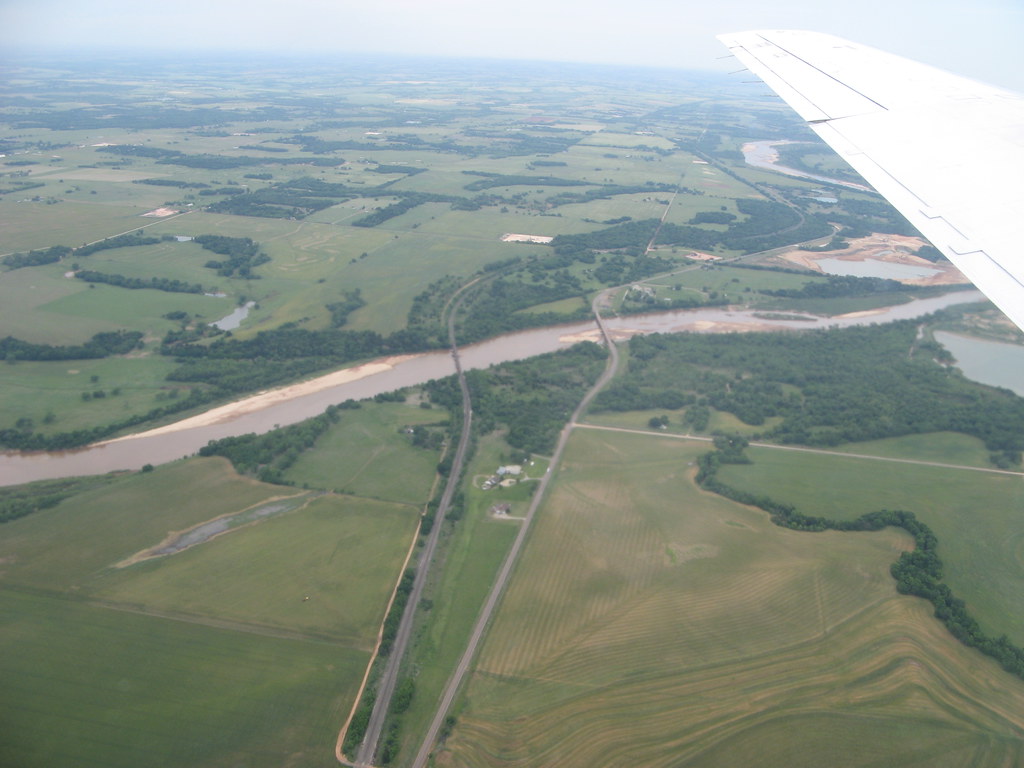
Ground zero for HI-SCALE was ARM’s Southern Great Plains (SGP) atmospheric observatory, where surface instruments are deployed in Oklahoma. The focus was the life cycle of shallow clouds. They play a role in the frequent convective storms that roll across the Great Plains. Such storms are triggered by intense turbulence that links the land surface to clouds.
The campaign opened a window onto the role of seasonal variations, changes in aerosol distribution, and the physics of clouds themselves──a miniature of similar micro- and macro-physical properties that play out across the world.
In ICLASS, some researchers study land-atmosphere interactions and the boundary layer linking the surface to the atmosphere. Others investigate aerosol-cloud interactions or deep convection. Hagos’s role is to help integrate all those processes into models.
Predicting Climate Extremes
For 14 years, Hagos has also been part of a DOE science focus area project called Water Cycle and Climate Extremes Modeling led by PNNL Battelle Fellow and atmospheric scientist Ruby Leung. (It’s part of the Regional & Global Model Analysis program area within EESM.)
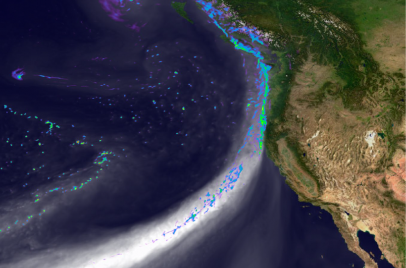
Much of his role with Leung is to look at droughts (as he did in graduate school) and rainfall variability, including links to monsoons, atmospheric rivers, tropical cyclones, and the Madden-Julian Oscillation (MJO).
The MJO is a periodic wave of storms that moves west to east through the tropics and circling the globe in 30 to 60 days. This phenomenon influences weather from the tropics into the earth’s mid-latitudes.
“We want to better predict climate extremes,” says Hagos, as well as understand the processes behind extreme precipitation. “Or, for that matter, extreme lack of precipitation.”
From Farm to City
Of course, it was his direct experience with “extreme lack of precipitation” that first inspired Hagos to study weather and climate. With unpredictable rainfall and no access to irrigation, the livelihoods of farmers where he grew up lived or died at the mercy of the rain. “We don’t have the infrastructure to predict it or prepare for it.”
Hagos says his parents were both from farm families but took agriculture in Eritrea “as an example of what not to do.”
His father joined the police force to escape farming and raise children in Asmara with Hagos’s mother, a homemaker. Schools in the capital city are the country’s finest.
Hagos is the youngest of six siblings. Three have doctoral degrees and are working in the United States. One, in Norway, is a soil and water conservationist. Two siblings have government jobs in Eritrea. His oldest brother followed in his father’s footsteps to become a police captain.
The city he grew up in offered more than the best education.
“If you had water at the right times,” said Hagos, Asmara, about a mile and a half above sea level and 15 degrees above the equator, “has a very pleasant climate, with comfortable temperatures all year round.”
A Place for Good Mentors
In school, Hagos became a “physics and mathematics person,” he says, and went on to the University of Asmara (B.S. Physics, 2000), the only four-year college in the country then. About 5% of students taking the national exam for college were admitted to degree programs. For those fortunate enough to make it, the government pays for the full cost of education.
“We need to work together, wherever we happen to be geographically. We need to look out for the less fortunate. Collectively, we have the tools to solve our water problems. Humankind is a very resourceful and cooperative species. That is what gives me hope.”
– Samson Hagos
And those who graduate with promise and high grades, as Hagos did, stay on as research assistants──“a kind of holding place for people with the potential to go further,” he says.
While in that holding place, a Canadian professor on staff, Rudolph “Rudy” Wiens, encouraged Hagos to aim high. He suggested at Cornell or Princeton, where some interesting work in climate dynamics was being done then.
And he encouraged Hagos to look beyond theoretical physics.
“There are enough theoretical physicists in the world right now,” he remembers Wiens saying. “You will be happier and more useful to society if you pursue climate sciences.”
Today, Hagos reflects, “I can’t say much about the useful-to-society part, but I sure am happy.”
Hagos says of Wiens, his first academic advocate, “You need a good mentor like that. Where I started and where I am now depended on the kindness of many, many people.”
On his office bookshelf at PNNL, Hagos still has the second edition copy of An Introduction to Dynamic Meteorology by James R. Holton, an iconic basic textbook Wiens presented him in 2000.
Getting to Cornell
At Cornell, the next good mentor──who admitted him to the program──was Kerry Cook.
Hagos remembers her surprise at the letter he sent, complete with test scores in the stratosphere.
“She used to joke that she thought it was some kind of Nigerian-Prince scheme,” he says, whose appeal for admission was too good to be true, “and that I had made up my transcript.”
In January 2002, Hagos arrived at Cornell, in snowy Ithaca, New York, wearing a light jacket and the wrong shoes. Where is a parched landscape when you need one?
In snow, walking up steep hills to the Cornell campus was difficult, he says, when slippery trails meant tacking back and forth like a sailboat.
After Cornell, Hagos spent a year at the University of Miami as a postdoctoral researcher working with Chidong Zhang, an expert in tropical atmospheric dynamics. (Zhang is now division director at the National Oceanic and Atmospheric Administration’s Pacific Marine Environmental Laboratory in Seattle.)
In late 2009, Zhang and Hagos coauthored a study of diabatic heating profiles relevant to large-scale circulations in the tropics. (A diabatic flow of air is one that transfers heat.) Diabatic heating in tropical convective (storm) systems influences large-scale circulations of air. Such heating structures, they found, are composed of various types of precipitating clouds.
Months in the Maldives
In November 2009, a month before the diabatic-heating paper appeared, Hagos started his now-14-year stint at PNNL.
At first, he split his research time between climate extremes with Leung and tropical convection with atmospheric scientist Sally McFarlane, now program manager for the ARM user facility.
Hagos’s work drew him into a coordinated set of field experiments in the equatorial Indian Ocean for four months spanning 2011 and 2012. The efforts were designed to improve the understanding of convective processes linked to the MJO.
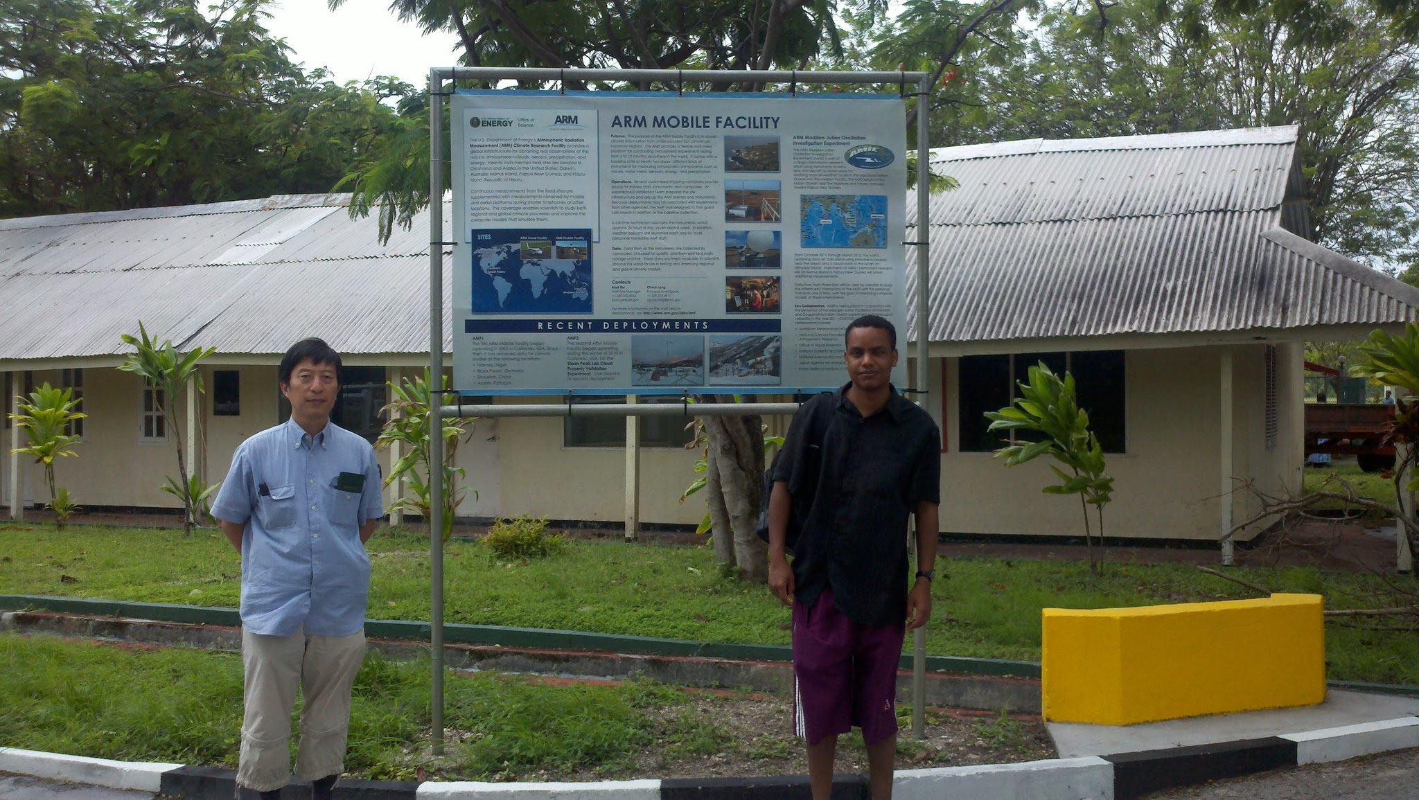
One of these field experiments, outlined in an ASR-funded study, was called the DYNAMO / AMIE on Addu Atoll in the Maldives, a “supersite” where Hagos worked and three radar systems were deployed. It combined the Dynamics of the MJO (DYNAMO) with the ARM MJO Investigation Experiment (AMIE).
Fresh Water and Optimism
Away from the office, Hagos does serious high-altitude hikes as he did in Eritrea as a younger man. But in Washington state, Colorado and elsewhere, Hagos is not slip-sliding as he once did in Ithaca. He has the correct boots and gloves and sometimes a pair of crampons.
In the right conditions, his wife (an orthopedic nurse) and his two daughters (9 and 5 years old) will come on hikes closer to home and to sea level.
To this day, as a witness to one of the 20th century’s worst droughts, Hagos looks at a glass of fresh water a little differently than many people.
But despite the often-tenuous availability of potable water in the world—especially at the margins of monsoonal regions of the Sahel, East Africa, the Middle East, and South Asia—he remains optimistic.
“We need to work together, wherever we happen to be geographically. We need to look out for the less fortunate,” says Hagos. “Collectively, we have the tools to solve our water problems. Humankind is a very resourceful and cooperative species. That is what gives me hope.”
# # #Author: Corydon Ireland, Staff Writer, Pacific Northwest National Laboratory
This work was supported by the U.S. Department of Energy’s Office of Science, through the Biological and Environmental Research program as part of the Atmospheric System Research program.